Ross Ice Shelf
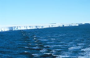
The nearly vertical ice front to the open sea is more than 600 kilometres (370 mi) long, and between 15 and 50 metres (50 and 160 ft) high above the water surface.
[4][5] On 5 January 1841, the British Admiralty's Ross expedition in the Erebus and the Terror, three-masted ships with specially strengthened wooden hulls, was going through the pack ice of the Pacific near Antarctica in an attempt to determine the position of the South Magnetic Pole.
Sir James Clark Ross, the expedition's commander, remarked: "It was an obstruction of such character as to leave no doubt upon my mind as to our future proceedings, for we might with equal chance of success try to sail through the cliffs of Dover".
[6] For later Antarctic explorers seeking to reach the South Pole, the Ross Ice Shelf became a starting area.
Amundsen wrote: "Along its outer edge the Barrier shows an even, flat surface; but here, inside the bay, the conditions were entirely different.
Even from the deck of the Fram we were able to observe great disturbances of the surface in every direction; huge ridges with hollows between them extended on all sides.
The greatest elevation lay to the south in the form of a lofty, arched ridge, which we took to be about 500 feet [150 m] high on the horizon.
All accounts without exception, from the days of Ross to the present time, had spoken of this remarkable natural formation with apprehensive awe.
Sometimes, fissures and cracks may cause part of the shelf to break off; the largest known is about 31,000 km2 (12,000 sq mi), that is, slightly larger than Belgium.
Many scientific teams researching the Antarctic have made camps on or adjacent to the Ross Ice Shelf.
[13] From 1967 to 1972 the Scott Polar Research Institute reported extensive observations using radio echo sounding.
The team was able to map the sea floor, study the tides, and assess the fish and various other forms of life in the waters.
Their scientists stated that the temperature of the warmest portion of the shelf is "only a few degrees too cool in summer presently to undergo the same kind of retreat process.
The report added that observations of "iceberg calving" on the Ross Ice Shelf are, in their opinion, unrelated to its stability.
One such opinion, given in 2006 based on a geological survey, suggested that the ice shelf had collapsed previously, perhaps suddenly, which could well happen again.
The hot water drill borehole at this site penetrated through over 500 m of snow and ice to an ocean cavity only 30 m deep at this location.
[22] As well as sampling the ocean and sediment, it was the first deployment beneath the Ross Ice Shelf of the Remotely operated underwater vehicle Icefin developed at Georgia Tech, a vehicle designed around parameters suitable for exploration of the liquid cavities of places like Europa.
[23] The same New Zealand team returned to another site along the Kamb coast in December 2021, this time drilling through an under-ice river that proved to be essentially oceanic.


Note humans for size comparison (dark spots at left between large chunks of sea ice , near the left image border). RV Nathaniel B. Palmer is in the distance.