Ventura River
[4] The Ventura River watershed encompasses 226 square miles (590 km2) consisting of steep mountains and foothills, with altitudes ranging from 6,010 feet (1,830 m) to sea level.
However, even in the subhumid upper basin, rainfall is infrequent – falling on as few days in a year as in hot, arid Phoenix, Arizona – but when rain does fall it can be extremely heavy with totals of 20 inches or 510 millimetres in a week not uncommon in the middle and upper basins.
Consequently, cycles of drought and flood are the norm: as an illustration, in the main settlement of Ojai since 1906, 67 percent of the years have had less than the mean rainfall.
Surface water readily disappears underground in some stream reaches (segments); in others, groundwater regularly feeds streamflow.
[4] The watershed's rugged topography, largely undeveloped status, and Mediterranean climate combine to make for an area of exceptional biodiversity.
The federally endangered southern California steelhead (listed in 1997) is of particular importance, given the watershed's often dry and always variable climate.
[6] Genetic analysis of the steelhead trout (Oncorhynchus mykiss) in the Ventura river watershed (both above and below Matilija Dam) has shown them to be of native and not hatchery stocks.
In 2008 the Los Angeles Regional Water Quality Control Board adopted the Ventura River Estuary Trash Total Maximum Daily Load (TMDL) to address the impairment and establish time schedule orders to improve water quality in this segment of the watershed.
The installation of stormwater treatment devices for the Ventura Freeway crossing was included in funding from the 2021 federal Infrastructure Investment and Jobs Act.
The site was also out of compliance with Los Angeles Water Quality Control Board's Ventura River Estuary Trash Total Maximum Daily Load.
The steep terrain of the Ventura River watershed, coupled with intense downpours that can occur in its upper portions, result in flash flood conditions where floodwaters rise and fall in a matter of hours.
The wastewater treatment plant below Foster Park was severely damaged and dumped raw sewage into the Ventura River.
[4] Unlike almost all of its neighbors in southern California, Ventura River watershed is 100% dependent on local water supplies.
Lake Casitas serves as the major surface water supply reservoir in the watershed and groundwater is heavily relied upon.
[4][16][17][18] Santa Barbara Channelkeeper filed a lawsuit in 2014 alleging the city of Ventura was taking too much water from the river, hurting habitat for steelhead trout and other wildlife.
The city filed a cross-complaint in response to bring in other users of the river, including the Casitas Municipal Water District.
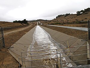
The Robles Diversion Dam was constructed on the Ventura River in 1958 to divert up to 107,800 acre-feet of water per year through a four-and-a-half mile canal to Casitas Reservoir.
[24] A major project underway to remove the Matilija Dam, in part to return access to the steelhead to spawning habitat while also enhancing the overall watershed.
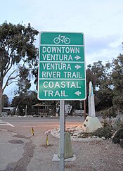
[33] The watershed is a recreation destination for hikers, walkers, bikers, surfers, campers, fishermen, boaters, backpackers, equestrians, and birders, as well as artists, spiritual seekers, and students of natural history.