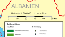
Linear scale
A scale bar is common element of map layouts.
On large scale maps and charts, those covering a small area, and engineering and architectural drawings, the linear scale can be very simple, a line marked at intervals to show the distance on the earth or object which the distance on the scale represents.
A person using the map can use a pair of dividers (or, less precisely, two fingers) to measure a distance by comparing it to the linear scale.
[1][2] Mariners generally use the nautical mile, which, because a nautical mile is approximately equal to a minute of latitude, can be measured against the latitude scale at the sides of the chart.
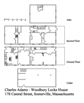
While linear scales are used on architectural and engineering drawings, particularly those that are drawn after the subject has been built, many such drawings do not have a linear scale and are marked "Do Not Scale Drawing" in recognition of the fact that paper size changes with environmental changes and only dimensions that are specifically shown on the drawing can be used reliably in precise manufacturing.