Anglo-Scottish border
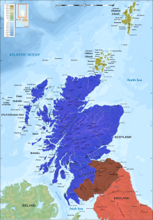
The Anglo-Scottish border (Scottish Gaelic: Crìochan Anglo-Albannach) runs for 96 miles (154 km) between Marshall Meadows Bay on the east coast and the Solway Firth in the west, separating Scotland and England.
[1] Despite this transaction, the control of Lothian was not finally settled and the region was taken by the Scots at the Battle of Carham in 1018 and the River Tweed became the de facto Anglo-Scottish border.
[3] For centuries until the Union of the Crowns, the region on either side of the boundary was a lawless territory suffering from the repeated raids in each direction of the Border Reivers.
Following the Treaty of Union 1706, ratified by the Acts of Union 1707, which united Scotland with England and Wales to form the Kingdom of Great Britain, the Border forms the boundary of the two legal systems as the treaty between Scotland and England guaranteed the continued separation of English law and Scots law.
From the Norman conquest of England until the reign of James VI of Scotland, who in the course of his reign became James I of England while retaining the more northerly realm, border clashes were common and the monarchs of both countries relied on Scottish Earls of March and Lord Warden of the Marches to defend and control the frontier region.
Edward would continue the war but would be unable to restore the puppet ruler Balliol to the throne and with the Treaty of Berwick (1357) Scottish independence was once again acknowledged with any pretence to territorial annexations dropped.
[7] Historic Border clans include the following: Armstrong, Beattie, Bannatyne, Bell, Briar, Carruthers, Douglas, Elliot, Graham, Hedley of Redesdale, Henderson, Hall, Home or Hume, Irvine, Jardine, Johnstone, Kerr, Little, Moffat, Nesbitt, Ogilvy, Porteous, Robson, Routledge, Scott, Thompson, Tweedie.
In 1605 he established a joint commission of ten members, drawn equally from Scotland and England, to bring law and order to the region.
In 1607 James felt he could boast that "the Middle Shires" had "become the navel or umbilic of both kingdoms, planted and peopled with civility and riches".
Despite these improvements, the Joint Commission continued its work, and as late as 25 September 1641 under King Charles I, Sir Richard Graham, a local laird and English MP, was petitioning the Parliament of Scotland "for regulating the disorders in the borders".
[12] For over three hundred years the area was effectively controlled by local clans, such as the Armstrongs, who successfully resisted any attempt by the Scottish or English governments to impose their authority.
[16] Berwickshire is in Scotland while the town is in England, although both Berwick and the lands up to the Firth of Forth belonged to the Kingdom of Northumbria in the Early Middle Ages.
[19] Berwick's MP Anne-Marie Trevelyan has resisted any change, arguing that: "Voters in Berwick-upon-Tweed do not believe it is whether they are in England or Scotland that is important.
Furthermore, to speak of England and Scotland at any time prior to the ninth century is anachronistic; such nations had no meaningful existence during the period of Roman rule.