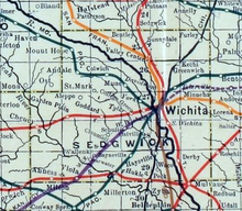
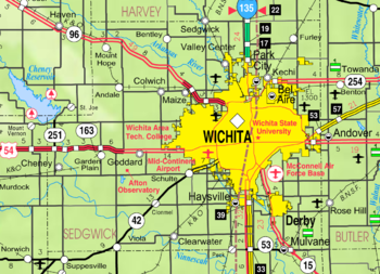
Sedgwick County, Kansas
The county was named for John Sedgwick, the highest ranking Union general killed during the American Civil War.
For many millennia, the Great Plains of North America was inhabited by nomadic Native Americans.
In 1803, most of the land for modern day Kansas was acquired by the United States from France as part of the 828,000 square mile Louisiana Purchase for 2.83 cents per acre.
[4] In 1887, the Chicago, Kansas and Nebraska Railway built a branch line north–south from Herington to Caldwell.
[5] This branch line connected Herington, Lost Springs, Lincolnville, Antelope, Marion, Aulne, Peabody, Elbing, Whitewater, Furley, Kechi, Wichita, Peck, Corbin, Wellington, Caldwell.
[citation needed] Ken Landwehr of the Wichita Police Department led the task force which captured Rader, setting a new standard of serial crime detection in the process, which is still studied by police departments across the world.
[6] Sedgwick County is part of the Wichita, KS Metropolitan Statistical Area.
Democratic strength is concentrated in Wichita, while the suburban areas are strongly Republican.
This makes it a bellwether in local Kansas elections, with the statewide winner almost always winning the county.
[18] The following public-use airports are located in Sedgwick County: The following are closed airports: School districts include:[19] List of townships / incorporated cities / unincorporated communities / extinct former communities within Sedgwick County.
† means a community is designated a Census-Designated Place (CDP) by the United States Census Bureau.
The cities of Bel Aire and Wichita are considered governmentally independent and are excluded from the census figures for the townships.


