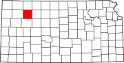
Sheridan County, Kansas
[1] The county was named in honor of Philip Sheridan, a Union general during the Civil War.
For many millennia, the Great Plains of North America was inhabited by nomadic Native Americans.
In 1802, Spain returned most of the land to France while keeping title to about 7,500 square miles.
In 1803, most of the land for modern day Kansas was acquired by the United States from France as part of the 828,000 square miles Louisiana Purchase for 2.83 cents per acre.
The population of Sheridan County grew in the early 20th century and peaked in 1930 at 6,038 residents.
Since then the population has steadily declined, as part of the general depopulation of the Great Plains.
27.60% of all households were made up of individuals, and 14.80% had someone living alone who was 65 years of age or older.
Since Michael Dukakis in the heavily drought-influenced 1988 election won almost 39 percent of the county's vote, no Democratic presidential candidate has topped 22 percent, and in 2016 Hillary Clinton’s share plummeted into single digits.


