Sedimentation enhancing strategy
Sedimentation enhancing strategies are environmental management projects aiming to restore and facilitate land-building processes in deltas.
[4] Interest in sedimentation enhancing strategies has recently increased due to their ability to raise land elevation, which is important for the long-term sustainability of deltas.
[1] When compared to conventional flood protection infrastructure such as embankments and seawalls, sedimentation enhancing strategies provide various benefits.
[5] Particularly considering uncertain future scenarios due to climate change, sea-level rise and peak river discharges, rigid flood defences may not be the optimal choice.
[6] Sedimentation enhancing strategies are more flexible and adaptable to changing environmental conditions, which makes them more likely to perform satisfactorily under different future scenarios.
[6] One major obstacle to the implementation of sedimentation enhancing strategies is that they require space which may not be available, as deltas are among the most densely populated regions in the world.
The 2 km wide Caernarvon diversion resulted in sediment deposition of up to 42 cm in the receiving area, creating a crevasse splay of approximately 130 km2 within three months.
[10] The currently planned Mid-Barataria, Lower-Barataria and Breton diversions have been specifically designed to capture and divert sediment from the Mississippi river and deposit it in the receiving basins to build land.
One control structure was built upstream to regulate the amount of water and sediment flowing from the Rio Magdalena into the Canal del Dique.
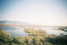
[18][19] Tidal water can bring in large concentrations of sediment from the sea into the river system, which deposit and accrete within the polder when flow velocities reduce.
Since then, the area has experienced multiple storms and extreme weather conditions, amongst which the flood disaster of 1953 which led to the construction of the Delta Works.
[20] The construction of dams, locks and storm surge barriers, and the strengthening and raising of dikes in the area, initially increased flood safety.
They question the idea of giving land back to nature as there is already a shortage of space in The Netherlands, and are afraid of increased salinisation in the area.
[28] Examples of strategies that stimulate low energy conditions are semi-permeable structures made of materials such as wood, twigs and brushwood.
This can be done by placing willow groynes, wooden posts connected with branches, in the ground along the kwelder, slowing down the water and encouraging sedimentation, which may eventually create new land.
The main idea behind this strategy is that mangroves seeds will colonise the area naturally when the shore bed level accretes high enough.
[40][41] The results of this restoration effort were that the Biesbosch area trapped approximately 46% of the incoming sediment, and the average aggradation rate was 5.1 mm per year.
[42][43] In February 2020, the Noordwaard polder flooded for the first time due to high water levels in the rivers caused by a storm and spring tide.
However, wetlands in the Sacramento-San Joaquin delta have been drained for agricultural purposes, so the soil is now situated at or above the water table where it can oxidize and decompose quickly resulting in a loss of elevation.
Adding a layer of water to the soil restores anaerobic conditions, which results in the accretion of new peat and increases surface elevation.
[47] Mangroves provide a wide range of ecosystem services, such as habitat for aquatic species, carbon sequestration, and their root systems reduce the impact of incoming waves and capture sediment resulting in land elevation gain.
[53] Restoration programs funded by the government and the oil and gas industry focus on replanting mangroves in abandoned shrimp ponds and encouraging combined mangrove-shrimp aquaculture, also called silvofishery.
The main reason for digging the channels was that fisheries in the Danube delta were negatively impacted by the limited freshwater delivery to the deltaic lakes and lagoons.
[3] This suggests that the artificial channels function as sediment traps that can assist in preventing delta drowning due to sea-level rise.
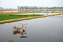
[58] Flooding is a vital source of fresh water and sediment supply to floodplains, important for land elevation maintenance, soil fertilization, and the support of healthy wetland ecosystems.
[60] A strategy to restore the input of freshwater and sediment to floodplains is intentionally breaching or significantly lowering levees to allow flooding to occur during peak discharges.
[57] Plans are being made to lower and breach levees in the upper Mekong delta in Vietnam near the border with Cambodia, an area that would normally flood during peak water discharge season from July to December.
With this full flood protection, farmers in the Mekong delta can produce more rice crops per year compared to a system with lower or no levees.
However, preventing floodwater and sediment from entering the Vietnamese floodplains resulted in increased peak river discharges and flood risks downstream, reduced flood retention capacity of floodplains, accumulation of agrochemicals in the soil, and reduced or eliminated sediment deposition contributing to accelerated land elevation loss.
This created a situation in which mangroves expanded rapidly at the expense of other saltmarsh vegetation, resulting in a deeper tidal inundation similar to that experienced with sea-level rise.