Shasta–Trinity National Forest
The 2,210,485 acre (894,552 Ha) forest encompasses five wilderness areas, hundreds of mountain lakes and 6,278 miles (10,103 km) of streams and rivers.
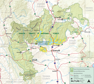
In descending order of land area, the forests are located in parts of Trinity, Shasta, Siskiyou, Tehama, Modoc and Humboldt counties.
It covers parts of Siskiyou, Shasta, Trinity, and Modoc Counties and has an area of 1,166,155 acres (471,926 ha).
Shasta, forest gives way once again to montane chaparral, subalpine woodlands, and ultimately to alpine rock and scree.
In moist stream canyons, other trees and shrubs prevail—bigleaf maple, western spicebush (Calycanthus Occidentalis), dogwood, white alder, and willows.
Huckleberry oak, shrub tanoak, greenleaf and pinemat manzanitas, and bush chinquapin, are important understory components.
On the serpentines of Trinity County's mid-elevation Klamath Mountains, incense-cedar and Jeffrey pine woodlands are inhabited by shrubby Congdon's silktassel, leather oak, and hoary manzanita.
Farther west, on the long ridge of South Fork Mountain that divides the Shasta–Trinity and Six Rivers National Forests, the tree form of tanoak grows mixed with Douglas-fir and golden chinquapin.
Montane meadows and streamsides in this region boast a diverse flora featuring abundant California pitcherplant and western azalea.
Much more detail on the vegetation zones of Mount Shasta, and their associated flora and fauna, can be found in C. Hart Merriam's important early biological survey, published in 1899.
The four major arms of the lake are: Sacramento, McCloud, Squaw Creek and Pit and have scenery as well as unusual geologic and historic areas.
The 500-mile (804.7 km) Volcanic Legacy Scenic Byway is an auto tour of northern California's volcanos and begins at Lassen Volcanic National Park, then to Mount Shasta and ends at Crater Lake National Park.