Sichuan Basin
In addition to being a dominant geographical feature of the region, the Sichuan Basin also constitutes a cultural sphere that is distinguished by its own unique customs, cuisine and dialects.
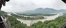
[2] The Jialing River enters from the north and flows across the entire width of the Sichuan Basin to meet the Yangtze at Chongqing.
[1] A moist, often overcast, four-season climate dominates the basin, with cool to mild winters occasionally experiencing frost, and hot, very humid summers.
With human settlement, agriculture has taken root across most of the fertile basin and reduced the original forest to small patches on hills and mountains including Mount Emei.
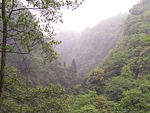
[3] A greater variety of natural landscapes and wildlife have been at least partially preserved in the mountains surrounding the basin where human settlement has been less intensive.
[9][10] Previously only known in fossils and thought to be extinct, the Dawn Redwood (Metasequoia glyptostroboides) was rediscovered in 1943 in the hilly Lichuan County, on the eastern mountain fringe of the Sichuan Basin.
[citation needed] Relative to the areas surrounding the upper Yellow River and the North China Plain, the Sichuan Basin has played a peripheral role in the development of Chinese civilization.
Due to the fertile agricultural characteristics of the basin, numerous cultures developed prior to integration with ancient Chinese dynasties.
[12] During the period of the Three Kingdoms, the Sichuan Basin was at the centre of another independent Shu State, until it was reunified with China in the 3rd century CE by the Jin dynasty.
[13] Owing to its vast fertile plains, the Sichuan Basin has long supported a high concentration of human population.
[1] The major population centres of Chengdu and Chongqing have flourished with their hinterlands providing staples such as rice, wheat, and barley.
In more recent times, the Sichuan Basin and the corridor between Chengdu and Chongqing have become developed as an economic centre known as the Chengyu Area.
In addition to Chengdu and Chongqing, significant cities found within the Sichuan Basin include Guangyuan, Mianyang, Deyang, Nanchong, Guang'an, Dazhou, Ya'an, Meishan, Leshan, Ziyang, Suining, Neijiang, Zigong, Yibin, and Luzhou.
Connecting the basin with the Yellow River valley to the north, the 4th century BCE Shu Roads were an engineering feat for their time.
[13] Transportation to the west from Sichuan has proven to be an even greater challenge, with steep mountains and deep valleys hindering movement.
Nevertheless, the Sichuan Basin has played a role as a stopover on the southern Silk Road and provided the most direct route between India and China.
The southern trade route to Tibet also passed through the basin, eventually crossing Kham and the Derge Kingdom to the west.
[26] All expressways that connect the Sichuan Basin with other parts of China have been designed to utilize a series of tunnels and bridges to cross the mountainous surrounding terrain.