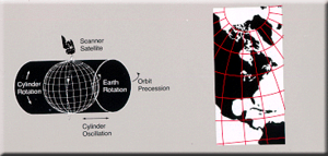
Space-oblique Mercator projection
It is a generalization of the oblique Mercator projection that incorporates the time evolution of a given satellite ground track to optimize its representation on the map.
Snyder had an interest in maps dating back to his childhood; he regularly attended cartography conferences whilst on vacation.
In 1972, the United States Geological Survey (USGS) needed to develop a system for reducing the amount of distortion caused when satellite pictures of the ellipsoidal Earth were printed on a flat page.
Colvocoresses, the head of the USGS's national mapping program, asked attendees of a geodetic sciences conferences for help solving the projection problem in 1976.
Scale is true along the ground track, varying 0.01 percent within the normal sensing range of the satellite.