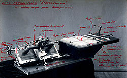
Stereoplotter
Although the specific devices have advanced technologically, they are all based on the apparent change in position of a feature in the two stereo photographs.
The stereoplotter requires two photographs that have considerable overlap (60%) and are corrected for distortion due to angle of photo.
The operator, using a special set of optics, would then see the image as three-dimensional due to the differing perspective of each photo.
The digital database is then combined in a graphics program with annotations and symbols, ultimately being used to produce the map printing plates with a photoplotter.
The stereoplotter serves an important need of allowing aerial photos to become the base for contours and elevation maps.
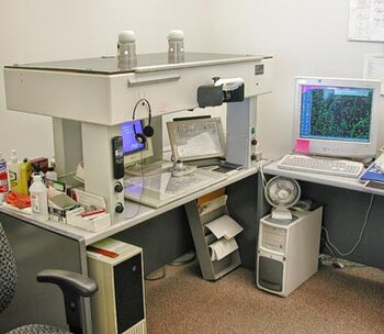
A stereoplotter is an instrument that uses stereo photographs to determine elevations for the purpose of creating contours on topographic maps.
Computers brought the capability to execute more precise calculations that ensure additional accurate output instead of approximations.
Analytical stereoplotters edged out their analog predecessors and became the primary method of acquiring elevation data from stereo photographs.
Analytical stereoplotters use a mathematical projection based on the co-linearity (two vectors pointing in the same direction) equation model.
The analytical stereoplotter measuring system is made up of an input device for the operator to move the elevation point in three dimensions.
With this information, the program then is able to set and locate points for both the interior and exterior of the elevation and record measurements.
The stereoplotter has been replaced by more modern photogrammetric methods, digital and automated, as in the case of structure from motion.