[4] Closure of the rift valley, starting 330 million years ago, resulted from the drift of the Falkland Plateau back towards Africa, during the Carboniferous and Early Permian periods.
Continued subduction of the paleo-Pacific Plate beneath the Falkland Plateau and the resulting further compression of the latter into Southern Africa, raised a mountain range of immense proportions to the south of the former rift valley.
Sediments, eroded from this immense Falkland Mountain range to the south, buried the folded Cape Supergroup rocks, and the plains beyond (to the north) to ultimately form the Karoo Supergroup, a sequence of sediments that eventually covered most of southern Africa and other parts of Gondwana.
The Falkland Mountain range had probably eroded into relative insignificance by the mid-Jurassic Period, and started drifting to the south-west soon after Gondwana began to break up 150 million years ago, leaving the Cape Fold Belt to edge the southern portion of the newly formed African continent.
Its subsequent burial under the other Formations in the Cape Supergroup, and thereafter under the sediments brought down from the Falkland Mountain range, compressed and partially metamorphosed the original sandy deposits into very hard quartzitic sandstones, which in their folded configuration form the peaks, steep cliffs and rugged crags of the Cape Fold Mountains.
They can easily be recognized at a distance as this formation readily erodes into fertile, gently sloping, green swaths in a landscape where this contrasts starkly with the bare rocky surfaces of the quartzites above and below.
[3][5] In the Cederberg this formation has been eroded by the wind into a wide variety of "sculptures", caves, and other fascinating structures for which these mountains have become well-known.
[1] The mudstone units commonly display ripple marks from the ebb and flow of tidal currents, as well as polygonal sand-filled mud cracks that indicate occasional exposure to desiccation.
[4][8] A particularly good example of these tracks can be viewed in the foyer of the Geology Department of the University of Stellenbosch, where a slab of Graafwater rock from the Cederberg mountains has been built into the wall.
Here they form the fertile soils on which the vines and fruit orchards of the Western Cape flourish with the help of irrigation from the rivers that have their sources in the surrounding mountains.
These rocks were laid down 370 - 330 million years ago in the silted up, and therefore shallow marine conditions of what remained of the Agulhas Sea.
[5][9] The termite species Amitermes hastatus is endemic to areas with sand eroded from Table Mountain Sandstone.
Table Mountain
seen from Signal Hill, across the
Cape Town
city bowl. The portion of the mountain made up of Table Mountain Sandstone is indicated on the right.
[
1
]
It is this mountain that has given its name to the geological structure that occurs in the mountains throughout the
Western Cape
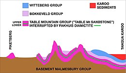
Schematic diagram of an approximate 100 km west-east (left to right) geological cross-section through the Cedarberg portion of the
Cape Fold Belt
(South Africa). The rocky layers (in different colors) belong to the
Cape Supergroup
. Not to scale. The green layer is the Pakhuis diamictite formation which divides the Table Mountain Sandstone (or
Peninsula Formation Sandstone
) into a lower and upper portion. It is the lower (older) portion that is particularly hard and erosion resistant, and, therefore, forms most of the highest and most conspicuous peaks in the Western Cape, as well as the steepest cliffs of the Cape Fold Mountains (including Table Mountain - see upper illustration).
[
2
]
The Upper Table Mountain Sandstone Formation, above the Pakhuis tillite layer, is considerably softer and more easily eroded than the lower Formation. In the
Cederberg Mountains
This formation has been sculpted by wind erosion into many fantastic shapes and caverns, for which these mountains have become famous.
[
3
]
The Graafwater Formation forms the lowermost layer of the Cape Supergroup in this region, but is, for simplicity, incorporated into the Table Mountain Sandstone Formation in this diagram.
Schematic geological west-east cross section through
Cape Peninsula
, based on a section through the Back Table just south of
Table Mountain
. Not to scale. On the Peninsula the basement layer consists in the main of
Cape Granite
. The Table Mountain Sandstone (in the same colour as in the diagram on the left) forms the steep escarpments that surround the approximately 5 km-wide central plateau. It consists of the layer below the "Pakhuis diamictite", of which there is only a trace at the highest point on Table Mountain at 1085 m above sea level. The lowermost formation of the
Table Mountain Group
is the "Graafwater Formation", which rests
unconformally
on the
Cape Granite base
, as opposed to the Malmesbury Formation base in most of the rest of the extent of
Cape Supergroup
in the
Western Cape
(see illustration above, on the left).
Kirstenbosch Botanical Gardens
, and all the major wines estates on the Peninsula are situated on the fertile (weathered) granite slopes on the east side of the mountain. The soils derived from Table Mountain Sandstone are very poor in nutrition.
Southern
Gondwana
during the
Cambrian
-
Ordovician
Periods. Today's continents into which this Supercontinent eventually broke up, are indicated in brown. A rift developed about 510 million years ago, separating Southern Africa from the Falkland Plateau. Flooding of the rift formed the
Agulhas Sea
. The sediments which accumulated in this shallow sea consolidated to form the Cape Supergroup of rocks, which form the Cape Fold Belt today. This portion of Gondwana was probably located on the opposite side of the South Pole from Africa's present position,
[
6
]
but compass bearings are nevertheless given as if Africa was in its present position.
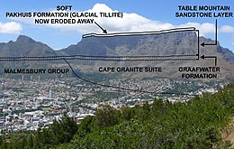
A west-east (left to right) geological cross section through
Table Mountain
on the
Cape Peninsula
, the
Cape Flats
(the isthmus connecting the Peninsula to the African mainland) and the
Hottentots-Holland
Mountains on the mainland, indicating how much of the Cape Fold Mountains has been eroded away.
[
1
]
Wolfberg Arch in the Cederberg, a "sculpture" carved by the wind in the softer, more easily eroded Upper Table Mountain Sandstone Formation, or Nardouw Formation as it is sometimes known.