El Tajín
El Tajín is a pre-Columbian archeological site in southern Mexico and is one of the largest and most important cities of the Classic era of Mesoamerica.
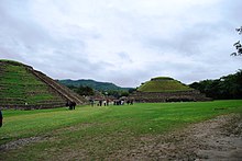
A part of the Classic Veracruz culture, El Tajín flourished from 600 to 1200 AD and during this time numerous temples, palaces, ballcourts, and pyramids were built.
[9] It is also the site of the annual Cumbre Tajin Festival, which occurs each March featuring indigenous and foreign cultural events as well as concerts by popular musicians.
The city is set in the low rolling mountains that lead from the Sierra Madre Oriental to the Gulf coast near the Tecolutla River.
[11] In ancient times, this city was located in the northeast corner of what is called Mesoamerica,[12] and controlled an area from between the Cazones and Tecolutla Rivers to the modern state of Puebla.
[6] When it was rediscovered by officialdom in 1785, the site was known to the local Totonac, whose ancestors may also have built the city, as El Tajín, which was said to mean “of thunder or lightning bolt”.
However, a series of indigenous maps dating from the time of the Spanish conquest, found in nearby Tihuatlan and now known as the Lienzos de Tuxpan, suggest that the city might then have been called “Mictlan” or “place of the dead”, a common denomination for ancient sites whose original names have been lost.
This name also appears in the Matricula de Tributos, a surviving Aztec tribute record, which later formed part of the Codex Mendoza.
[1] The religion was based on the movements of the planets, the stars and the Sun and Moon,[14] with the Mesoamerican ballgame and pulque having extremely important parts.
[6] The city began to have extensive influence starting around this time,[12] which can be best seen at the neighboring site of Yohualichan, whose buildings show the kinds of niches that define El Tajin.
[11] Evidence of the city's influence can be seen along the Veracruz Gulf coast to the Maya region and into the high plateau of central Mexico.
[12] El Tajín prospered until the early years of the 13th century, when it was destroyed by fire, presumably started by an invading force believed to be the Chichimecs.
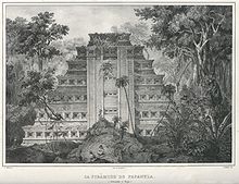
[2] In 1785, an official by the name of Diego Ruiz stumbled upon the Pyramid of the Niches, whilst looking for clandestine tobacco plantings breaching the royal monopoly in this isolated area rarely visited by the authorities.
[22] The publication of the pyramid's existence in the Gaceta influenced academic circles in New Spain and Europe, attracting the attention of antiquarians José Antonio de Alzate y Ramírez and Ciriaco Gonazlez Carvajal, who wrote about it.
[12] German architect Charles Nebel visited the site in 1831 and was the first to graphically and narratively detail the Pyramid of the Niches as well as the nearby ruins of Mapilca and Tuzapan.
[23][24] The first archeologists reached the site in the early 20th century and included Teobert Maler, Edward Seler, Francisco del Paso y Troncoso and Herbert and Ellen Spinden.
Starting from 1938, excavation and reconstruction work was sponsored by INAH and headed by Jose Garcia Payon,[15] uncovering platforms, ballcourts and part of Tajín Chico with its palaces.
[6] Unlike the highly rigid grid patterns of ancient cities in the central highlands of Mexico, the builders of El Tajin designed and aligned buildings as individual units.
[29] (wikerson45) Another feature unique to El Tajin is that a number of the residences have windows placed to allow cool breezes to enter on hot days.
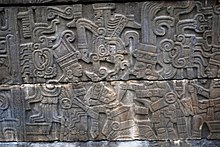
The most impressive of these panels are on the South Ballcourt which contain images of underworld deities and a ballplayer being decapitated in order to approach the gods and ask for pulque for his people.
[8] Air pollution from oil-drilling platforms and power stations along the coast causes high levels of acid rain in the region, which is eroding the intricately carved reliefs on the soft limestone buildings “at an alarming rate”, according to Humberto Bravo of the University of Mexico's Center for Atmospheric Sciences in 2007.
In being named a World Heritage Site in 1992, new facilities have been added to this area, such as a cafeteria, information services, a park and administrative offices.
It hosts fairs, conventions and other events, including part of the annual Cumbre Tajín cultural festival which is held in March.
[32] The site museum is divided into two parts: an enclosed building and a roofed area covering large stone sculpture fragments.
What is unusual about this construction and others in the city are the addition of decorative niches with the top capped by what Jose Garcia Payon called a "flying cornice", a triangular overhang.
The larger tablets have depictions of the rain god, or a ruler dressed as the deity, involved in several ritual or mythological scenes.
The friezes running along the upper edges of the court are composed of interlocking scroll figures, each containing a central element of a head and an eye.
The sculpted panels on these walls remain largely intact and show in step-by-step fashion how the ball game was played here, complete with ceremonies, sacrifice and the response of the gods.
[56] The southeast panel illustrates the opening ritual when the principal participant is elaborately dressed and is being handed a bundle of spears.
The north central panel represents the continuation of the ritual in the afterlife, and shows how the events of the game connect the society of El Tajin to the gods.

