Technical geography
[6][15] Technical geography is highly theoretical and focuses on developing and testing methods and technologies for handling spatial-temporal data.
[1][8] To this end, technical geographers often adapt technology and techniques from other disciplines to spatial problems rather than create original innovations, such as using computers to aid in cartography.
[12][16] They also explore adapting techniques developed for one area of geography to another, such as kriging, originally created for estimating gold ore distributions but now applied to topics such as real estate appraisal.
[1][20] More than just reducing the overall level of information, cartographic generalization helps discover patterns and trends in data that underlie many techniques and technologies employed and investigated by technical geographers.
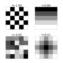
[1][20] Autocorrelation is a statistical measure used to assess the degree to which a given data set is correlated with itself over different time intervals or spatial distances.
[1] It enhances the ability to model, analyze, and interpret spatial patterns and relationships, supporting various applications from environmental monitoring and urban planning to resource management and public health.
[1] Spatial and temporal frequency are core concepts in technical geography because they are fundamental to understanding and analyzing geographic phenomena.
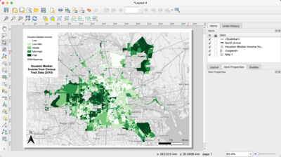
[27][28][29] Cartographic generalization is the process of simplifying the representation of geographical information on maps, making complex data more understandable and useful for specific purposes or scales.
[20] This process involves selectively reducing the detail of features to prevent clutter and ensure that the map communicates the intended information effectively.
[1] The primary goal of cartographic generalization is to balance detail with readability, ensuring that the map serves its intended purpose without sacrificing essential information.
[20] It balances the need for detail with the practical limitations of scale and medium, enhancing the effectiveness of maps as tools for communication, analysis, and decision-making.
[7][30][Note 1] This 1749 book was divided into four parts, one of which was named "containing technical geography", which focused on both globes and maps, including concepts of cartographic design, and projection.
[7] This publication defines technical geography with the following: "The Description confider'd as to Form is of three Sorts; The first exhibits the Earth, by a Draught or Delineation; the second by Tables, or Registers; and the third by Treties or Discourse.
Technical geography as a term is more than place name recollection and toponymy; it involves spatial relationships between points and theory.
[33] For example, the Kitab al-Buldan, written by Ibn al-Faqih between 902 and 903 C.E., was described by Henri Massé as "technical geography [including] themes of adab.
[40][41] By 1917, technical geography was included among courses taught at some British schools, alongside mathematics, chemistry, and other natural sciences.
[1][44][45] Before this, the techniques and methods of handling spatial information were primarily focused on supporting human or physical geography, rather than a subject of study itself.
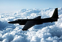
World War II, which saw the extensive use of cartography and air photos, revolutionized these techniques and brought a new focus on the benefits they offered.
To address this, geographers began to debate the merits of more scientific and methods-based approaches to the discipline and advocate for the benefits these methods had to other technical courses.
[66] These terms often compete and overlap with each other and often originate in separate countries, such as geographic information science in the United States, geomatics in France, and geoinformatics in Sweden.
[75] GIS serves as the primary technology driving the field of geodesign by enabling real-time feedback in considering geography and landscape with community planning.
Many authors with great ease announce the origination of a new science, frequently not caring for the proper justification of its name definition.
The lack of specific terminological conditions, determined boundaries, or scopes of such definition use, encourages one to define the next terms, and the next science and research disciplines.During the early days of the quantitative revolution, the term quantitative geography emerged as a subdiscipline within technical geography, focusing exclusively on new quantitative methods, such as spatial statistics, time geography (including visualizations such as the space-time prism and continuous transportation modeling approach), and GIS, for handling spatial-temporal data generated by novel technology like GPS and remote sensing.
English-speaking Canadians Pierre Gagnon and David Coleman translated the term as "geomatics", which was popularized in Canada through the 1980s and early 1990s.
[1][2] In the late 1980s, the term geoinformatics was coined by Swedish scientist Kjell Samuelson and later defined in the 1990s as the science of integrating spatial data derived from various technologies, such as remote sensing, GPS, and GIS.
[1] In response to this, in 2006, the peer-reviewed journal Geographia Technica was established to serve as an outlet for research employing quantitative, technical, and scientific methods within geography.
[1][103][40] In a 2016 paper within this journal, Ionel Haidu stated: "The risk is that non-geographers mastering these methods analyze the spatiotemporal data and information better than the geographers.
As technology such as GIS began to dominate geography departments, the need to develop new curriculum to teach the fundamental concepts became apparent.
[106] In response to this in 2006 the UCGIS published Geographic Information Science and Technology Body of Knowledge (GISTBoK), building on the "Model curricula" of the mid 90s.
[3][110] Some of the discrepancy in terminology is due to different cultures and languages having their own method of organization; for example, the term "information geography" is popular in research from China to describe similar concepts.