The Ridgeway
The high dry ground made travel easy and provided a measure of protection by giving traders a commanding view, warning against potential attacks.
In medieval times and later, the Ridgeway found use by drovers, moving their livestock from the West Country and Wales to markets in the Home Counties and London.
[5] One of fifteen long-distance National Trails in England and Wales, the Ridgeway travels for 87 miles (140 km) northeast from Overton Hill within the Avebury World Heritage Site to Ivinghoe Beacon near Tring.
At Marlborough it meets the Wessex Ridgeway, a footpath opened in 1994 which follows the southwest section of the ancient track into Dorset, as far as Lyme Regis.
[6] It is possible to join or leave the trail at other locations with public transport links, including Avebury, Swindon, Wantage, Wallingford, Princes Risborough and Tring.
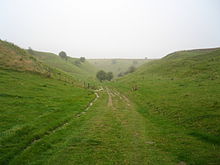
The Ridgeway's surface varies from chalk-rutted farm paths and green lanes (which have a propensity for becoming extremely muddy and pot-holed after rain) to small sections of metalled roads.
The 43 miles (69 km) of the Trail to the west of the River Thames has no sections of public footpath and is therefore open along its entire length to cyclists and those on horseback.