Timeline of the 2021 Atlantic hurricane season

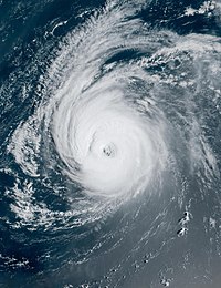
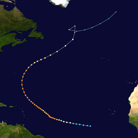
It made landfall in Louisiana with maximum sustained winds of 150 mph (240 km/h), destroying coastal communities in its path; parts of the New Orleans metropolitan area were left without power for several weeks.

[7] Over half of those deaths occurred in New York and New Jersey, as the hurricane's remnants brought rains that triggered widespread flooding throughout that region.

[6] Additionally, heavy rains caused widespread flooding and landslides across Venezuela as Ida's precursor tropical wave passed though the southeastern Caribbean Sea, resulting in at least 20 deaths.

[8] In April 2022, the name Ida was retired from reuse in the North Atlantic by the World Meteorological Organization due to the extraordinary amount of damage and number of fatalities it caused.

Additionally, figures for maximum sustained winds and position estimates are rounded to the nearest 5 units (knots, miles, or kilometers), following National Hurricane Center practice.

A satellite image of Subtropical Storm Ana on May 22, 2021.
Subtropical Storm Ana northeast of Bermuda on May 22
A satellite image of Tropical Storm Claudette on June 21, 2021.
Tropical Storm Claudette off the coast of North Carolina on June 21
A satellite image of Hurricane Elsa on July 2, 2021.
Hurricane Elsa after passing through the Lesser Antilles on July 2
A satellite image of Tropical Storm Fred on August 16, 2021
Tropical Storm Fred approaching the Florida Panhandle on August 16
A satellite image of Hurricane Ida approaching landfall in Louisiana on August 29, 2021.
Hurricane Ida approaching Louisiana on August 29
A satellite image of Hurricane Larry in the open Atlantic Ocean on September 5, 2021.
Hurricane Larry in the open Atlantic Ocean on September 5
An infrared composite satellite image of Hurricane Nicholas near the coast of Texas on September 14, 2021.
Hurricane Nicholas near the coast of Texas on September 14
An infrared satellite loop of Tropical Depression Sixteen strengthening into Tropical Storm Peter on September 19, 2021.
Infrared satellite loop of Tropical Storm Peter developing east of the Leeward Islands on September 19
A map plotting the track and intensity of Hurricane Sam at 6-hour intervals during its September 22 – October 5, 2021 lifetime.
Map plotting the track and the intensity of Hurricane Sam
A satellite image of Subtropical Storm Wanda over the Atlantic Ocean on October 31, 2021.
Subtropical Storm Wanda over the Atlantic Ocean on October 31