GeoJSON
GeoJSON[1] is an open standard format designed for representing simple geographical features, along with their non-spatial attributes.
The features include points (therefore addresses and locations), line strings (therefore streets, highways and boundaries), polygons (countries, provinces, tracts of land), and multi-part collections of these types.
In April 2015 the Internet Engineering Task Force founded the Geographic JSON working group[5] which released GeoJSON as RFC 7946 in August 2016.
[11] In addition, TopoJSON facilitates applications that use topology, such as topology-preserving shape simplification, automatic map coloring, and cartograms.
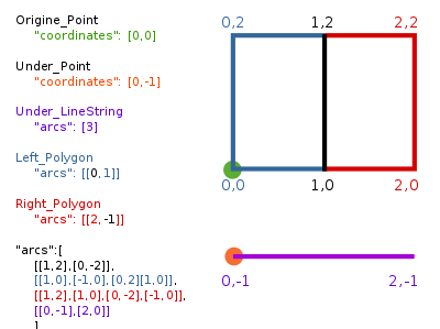
[13] Given a GIS shape near coordinates latitude 0° and longitude 0°, a simple but valid and complete topojson file containing all metadata, Polygon, LineString, Point elements, arcs and properties is defined as follows: