Transport in Niger
Camel caravan transportation has historically been important in the Sahara desert and Sahel regions, which cover most of northern Niger.
Border controls and import/export duties are monitored by the independent tax police, the "Police du Douanes.” Air traffic control is monitored and operated in conjunction with Pan-African ASECNA, based on one of its five air traffic zones at Niamey's Hamani Diori International Airport.
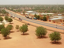
26 towards Abala, veers off onto a dirt track (locally called a Piste) from the villages of Talcho to Sanam, where RN26 also terminates from another direction.
RN25 then continues along a piste through a largely uninhabited desert for almost 100 km before reaching the city of Tahoua, served by other major paved roads.
[1] [2] [3] Nigeriens in both urban and rural areas rely on a combination of motor vehicles and animals for the transport of themselves and commercial goods.
In cities, public transport systems are largely absent, so a variety of privately operated services carry many urban dwellers.
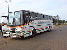
Intercity coach systems are the standard form of personal transport, with the government operating one bus service (the SNTV) and a multitude of buses, "bush taxis" (taxi brousse), small vans, and semi-converted trucks taking passengers and goods.
[1] Animals pulling wagons and loaded camel trains remain a common sight on Nigerien roads.
[1] Vehicles in Niger are subject to the "Laws of the Road" ("Code de la route”), for which the government began a continuing reform in 2004-2006, which are based substantially on French models.
[7] A 2009 enforcement blitz in Niamey resulted in numerous arrests of owners of small motorbikes, common in Nigerien cities.
Speaking before a National Assembly session, Bagoudou said that the 42.2 billion CFA francs spent on medical costs for road accident victims accounted for around 25% of the 2008 budget of the Nigerien Ministry of Public Health.
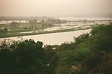
In the navigable stretches, shallows prevent all but the small draft African canoes (Pirogues and Pinnases) from operating in many areas.
Abidjan was in the process of regaining Niger's port trade, following the disruption of the Ivorian Civil War, beginning in 1999.
French Uranium mines in Arlit, which produce Niger's largest exports by value, travel through this port to France or the world market.
In 2012, a multi-national railway system was proposed to connect Benin, Niger, Burkina Faso and Ivory Coast.