Transport in Rome
Rome has an extensive internal transport system and is one of the most important road, rail and air hubs in Italy.
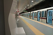
Roma servizi per la Mobilità is the municipally-owned public transport agency which is in charge of programming bus routes and providing real-time information and services to the user.
Inaugurated in post-war Italy in 1955 during the reconstruction and on the verge of the Italian economic miracle, it was designed and built for the 1942 universal exhibition (Esposizione Universale Roma, which is now the current business center of Rome) desired by the fascist regime, which never took place due to the outbreak of the World War II.
Whereas most FS-Regionale lines (Regional State Railways) provide a largely suburban service with more than twenty stations scattered throughout the city.
[12] Cotral is the main interurban bus operator in the Lazio region, connecting all the municipalities except from the insular Ponza and Ventotene.
Cotral's main departure points in Rome are the bus stations at the metro stops Tiburtina, Anagnina, Cornelia, Ponte Mammolo and Laurentina, connecting the Italian capital to various destinations in the region.
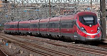
Located in the center of the Italian Peninsula, Rome is the main railway hub in central Italy, connected by high-speed lines with Florence, Bologna, Milan, Turin, Venice, Naples and Salerno.
[15] This issue is caused mainly by the undersized public transport network and the extremely high cars per capita ratio in the city.
[16] Chronic congestion caused by cars led to the partial banning of motor traffic from the central part of the city during workdays, from 6 am to 6 pm.
[17] This area is called Zona a Traffico Limitato (ZTL), motor traffic limited zone.
[18] Heavy traffic due to night-life crowds during weekends led in recent years to the creation of other ZTLs in the Trastevere, San Lorenzo, Testaccio and Monti districts during the night.
Private mobility is also regulated by the environmental protection areas of the "Anello ferroviario e della Fascia verde" (”Railway Ring and the Green Belt” or simply "Green Zone"), which are closed to the most polluting vehicles either permanently or temporarily;[19] and paid parking in the historic center and surrounding neighborhoods, delimited at street level by blue lines, while white lines indicate free parking.
Rome's cycle path network extends for approximately 320km (198,84mi) and winds through parks and historic villas and along the city's main streets.
[21] In 2024, the largest construction site for the expansion of Rome's cycle path network began, the "GRAB" ("Grande raccordo anulare delle bici"), a cycle/pedestrian ring that extends for 45 kilometers within the city of Rome, to connect the existing cycle path network and the one currently being designed, in order to make the new infrastructure an integral part of the urban mobility system.
A fourth airport in the eastern part of the city, the Aeroporto di Centocelle (dedicated to Francesco Baracca), is no longer open to civil flights; it hosts the Comando di Squadra Aerea (which coordinates the activities of the Aeronautica Militare) and the Comando Operativo di Vertice Interforze[26] (which coordinates all Italian military activities), although large parts of the airport are being redeveloped as a public park.
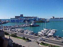
The Marina of Rome is a tourist port located in the Ostia district, between its beaches and the mouth of the Tiber.
[32] The average amount of time people spend commuting with public transit in Rome, for example to and from work, on a weekday is 79 min.