Transverse Ranges
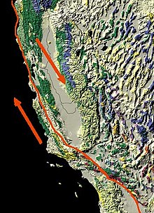
[1][2][3][4] The ranges extend from west of Point Conception eastward approximately 500 kilometers into the Mojave and Colorado Desert.
The geology and topography of the ranges express three distinct segments that have contrasting elevations, rock types, and vegetation.
The eastern segment extends from the Cajon Pass at the San Andreas fault eastward to the Colorado Desert.
Onshore the Los Angeles Basin lies at the southern boundary of the western and central segments of the ranges.
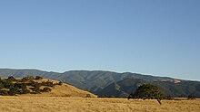
The Transverse Ranges manifest themselves as a series of roughly parallel ridges with an average height of 3,000–8,000 feet (910–2,440 m).
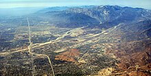
This results in significant traffic issues throughout Southern California when a pass has to be shut down due to heavy snow or construction.
Likewise, the Tehachapi Mountains north of the Mojave Desert, although nearly transverse, are the southern end of the Sierra Nevada.
Their orientation along an east–west axis as opposed to the general northwest–southeast trend of most California ranges results from a pronounced left step in the San Andreas Fault that occurred in the Pliocene (c. 4 million years ago) when southern reaches of the fault moved east to open the Gulf of California.
Exposed plutonic rocks from the Mesozoic, mostly granites, can be found on Mount Pinos and generally in regions east of Tejon Pass.
The western segment is distinctive for the large thickness of Cretaceous and Cenozoic sedimentary rocks, estimated to be up to 10 kilometers.
These are mostly marine in origin with a marked change to red beds of river systems of Oligocene age in the western and central segments.
Limestones and dolomites of the marine Miocene Monterey Formation are found in the Santa Ynez Mountains and in the Coast Ranges to the north.
The distinctive feature of the Transverse Ranges besides their anomalous orientation is that they are bounded by east-west trending faults.
[10] Between the western segment and the Peninsular Ranges to the south is the complex Malibu Coast—Santa Monica—Hollywood fault, which exists as the border between these two mostly geologically unitary provinces.
Several dozen fields are found onshore and offshore, particularly in the Santa Barbara Channel and Ventura Basin.
[17]The plant place of the Transverse ranges include coastal sage scrub, oak woodland and savanna, and pinyon-juniper woodland at lower elevations, and yellow pine forest, Lodgepole Pine, and subalpine forest at higher elevations.
The Los Angeles Basin, which includes the portion of Los Angeles County south of the Santa Monica Mountains and most of Orange County, and the Inland Empire basin, which includes the cities of San Bernardino and Riverside, lie between the Transverse Ranges and the Peninsular Ranges to the south.
These highways link Southern California with places to the north and northeast like San Francisco and Las Vegas, respectively.