Tropical Storm Abby (1964)
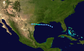
That day, an eye rapidly formed within the system and it became a tropical storm just 60 mi (95 km) southeast of Galveston, Texas.
Only two structures sustained damage in Matagorda, one being destroyed by a possible tornado, and the remaining effects resulted from flooding in Jackson and Victoria Counties.
[1] According to the Atlantic hurricane database (referred to as HURDAT), the system developed into a tropical depression by 18:00 UTC (1:00 p.m. CDT) that day, with its center located roughly 160 mi (255 km) south-southeast of the Mississippi River Delta.
During the afternoon hours, banding features consolidated around a developing eye and weather reconnaissance planes were dispatched to the system.
[3] It is estimated that the depression became a tropical storm by 12:00 UTC (7:00 a.m. CDT), roughly 60 mi (95 km) southeast of Galveston, Texas.
[2] Operationally, the system was not even monitored as a depression this time, with the classification and naming of Tropical Storm Abby occurring at 16:00 UTC (11:00 a.m. CDT) on August 7.
[1] Around 16:00 UTC (11:00 a.m. CDT) on August 7,[4] reconnaissance measured a central barometric pressure of 1000 mbar (hPa; 29.53 inHg) within Abby, the lowest in relation to the system.
[7] Weakening to a depression hours later, Abby ultimately degenerated into an area of showers and dissipated southwest of San Antonio by 12:00 UTC (7:00 a.m.
"[5][9] Gale warnings were raised from Galveston to San Antonio immediately following the storm's formation and were kept in place through the morning of August 8.
[1] Near the town, a possible tornado unroofed a barn and tossed the structure 225 ft (69 m); this building previously had withstood the effects of Hurricane Carla in 1961.
Tropical storm (39–73 mph, 63–118 km/h)
Category 1 (74–95 mph, 119–153 km/h)
Category 2 (96–110 mph, 154–177 km/h)
Category 3 (111–129 mph, 178–208 km/h)
Category 4 (130–156 mph, 209–251 km/h)
Category 5 (≥157 mph, ≥252 km/h)
Unknown
