Tropical Storm Marco (2008)
[1] The thirteenth named storm of the 2008 Atlantic hurricane season, Marco developed out of a broad area of low pressure over the northwestern Caribbean during late September 2008.
After crossing the southern end of the Yucatán Peninsula and emerging into the Bay of Campeche, the low was declared Tropical Depression Thirteen early on October 6.
Tropical Storm Marco originated in a broad area of low pressure that persisted over the northwestern Caribbean in early October, 2008.
Forecasters anticipated intensification up until landfall because of the storm's well-developed outflow and the low wind shear and high sea surface temperatures in its path.
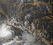
Early on October 7, Marco reached its peak intensity with winds of 65 mph (105 km/h) and a minimum pressure of 998 millibar (hPa; 29.47 inHg).
[4] The storm maintained a small area of deep convection, averaging 9.2 miles (14.8 km) in diameter, as it continued moving towards the west-northwest.
[5] Shortly after reaching peak intensity, tropical storm force winds extended 11.5 miles (18.5 km) from the center of Marco.
[10] Officials in Veracruz, in their post-storm damage survey, reported that two rivers, the Quilate and Tenoch, overflowed their banks due to rains produced by Marco.
[18] In all, Marco's impact was light; minimal damage was recorded, and none of the estimated 400,000 people affected by the storm sustained injury.
[1][19] In the wake of Marco, the General Coordination of Civil Protection of the Ministry of the Interior declared a state of emergency for 48 municipalities in Veracruz.

Tropical storm (39–73 mph, 63–118 km/h)
Category 1 (74–95 mph, 119–153 km/h)
Category 2 (96–110 mph, 154–177 km/h)
Category 3 (111–129 mph, 178–208 km/h)
Category 4 (130–156 mph, 209–251 km/h)
Category 5 (≥157 mph, ≥252 km/h)
Unknown