Tropical Storm Barry (2001)
The wave entered the Caribbean on July 29 and spawned a low-pressure area, which organized into Tropical Storm Barry on August 3.
The precursor tropical wave to Barry dropped large amounts of rain on southern Florida, leading to significant flooding and structural damage.
The wave moved into the eastern Caribbean on July 29, and its convection continued to increase while it tracked west-northwest over the subsequent few days.
The disturbance emerged into the Gulf of Mexico on August 1, with rainfall noted over southern Florida and the western tip of Cuba.
That same day, a broad low-pressure system developed along the wave near the Dry Tortugas at the end of the Florida Keys, which began to intensify as it moved northwestward.
At around 1800 UTC on August 2, an Air Force Reserve Hurricane Hunter aircraft investigating the system discovered that the low had organized into a tropical storm, which received the name Barry.
There is uncertainty as to whether Barry actually held tropical characteristics at the time of designation, because of an upper-level low that was situated over the cyclone's surface center.
A strong, upper-level cyclonic shear axis extended from just south of Cape Hatteras to near Brownsville, Texas, which prevented Barry from accelerating in forward speed.
[3] The ridge over the United States weakened, thus collapsing the steering pattern; this resulted in a west-southwestward drifting motion of the tropical storm by around August 3.
[1] Early on August 3, strong westerly winds prevailed, and separated the center of circulation from what limited convection remained.
[7] Prior to landfall, banding features developed on the eastern half of the circulation, despite some residual westerly shear.
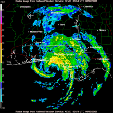
At 0500 UTC on August 6, Barry increased in forward speed and made landfall at Santa Rosa Beach, Florida with winds of 70 mph (110 km/h).
[9] Moving inland, the system weakened rapidly to a tropical depression; the National Hurricane Center issued its last advisory on the storm early on August 6.
[14] Forty C-130 cargo aircraft and about 300 personnel from Hurlburt Field were moved to the Little Rock Air Force Base in Arkansas to flee the storm's projected path.
The rain helped relieve persistent drought conditions;[1] however, it caused significant flooding in Martin County on August 2, where a total of 300 homes received water damage.
[1] Light to moderate winds were widespread, causing damage throughout Walton, Washington, Bay, Calhoun, Gulf and Okaloosa counties.
[27] Window damage was reported at a high-rise condominium building in Destin, while nearby, the Mid-Bay Bridge was closed due to high winds.
[28] Tropical Storm Barry dropped light to moderate rainfall across Alabama, peaking at 4.57 in (116 mm) near the town of Evergreen.

Tropical storm (39–73 mph, 63–118 km/h)
Category 1 (74–95 mph, 119–153 km/h)
Category 2 (96–110 mph, 154–177 km/h)
Category 3 (111–129 mph, 178–208 km/h)
Category 4 (130–156 mph, 209–251 km/h)
Category 5 (≥157 mph, ≥252 km/h)
Unknown