Tropical Storm Allison
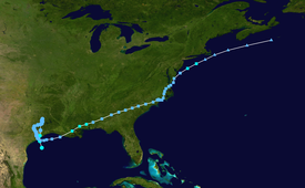
The storm developed from a tropical wave in the northern Gulf of Mexico on June 4, 2001, and struck the upper Texas coast shortly thereafter.
Following the storm, President George W. Bush designated 75 counties along Allison's path as disaster areas, which enabled the citizens affected to apply for aid.
After moving across South America and the southwestern Caribbean Sea, the wave entered the eastern North Pacific Ocean on June 1.
[3] Early on June 5, satellite imagery suggested that a tropical depression was forming in the northwest Gulf of Mexico, which was furthered by reports of wind gusts as high as 60 mph (95 km/h) just a few hundred feet above the surface, towards the east side of the system.
[3] The storm initially moved very little, and the presence of several small vortices from within the deep convection caused difficulty in determining the exact center location.
[8] Shortly after being downgraded to a tropical depression, surface observations showed an elongated circulation with a poorly defined center, which had reformed closer to the deep convection.
[13] The low once again became nearly stationary about 60 mi (97 km) south of Galveston, Texas, and despite more favorable upper-level winds, it showed no signs of redevelopment.
While the subtropical depression moved eastward, a new low level circulation redeveloped to the east, and Allison quickly made landfall on Morgan City, Louisiana on June 11.
[3] The storm intensified further to attain sustained winds of 45 mph (75 km/h) and a minimum barometric pressure of about 1,000 mbar (29.53 inHg) near Mclain, Mississippi, accompanied by a well-defined eye-like feature.
With an average lead time of 24 minutes, the National Weather Service in Lake Charles, Louisiana issued 47 flash flood warnings.
[26] In Tallahassee, Florida, a shelter opened the day before Allison's movement northward through the area, seven staff members housing 12 people.
Allison caused approximately $8.5 billion in damage (2001 USD),[28] making it the costliest tropical cyclone that was never a major hurricane on record in the Atlantic basin.
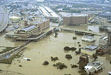
Combined with waves on top, areas of Galveston Island experienced a wall of water 8 feet (2.4 m) in height, creating overwash along the coastline.
Flash flooding continued for days,[11] with rainfall amounts across the state peaking at just over 40 inches (1,000 mm) in northwestern Jefferson County.
Houston Intercontinental Airport, which typically receives 46.07 inches (1,170 mm) of rain in a year, experienced 35.7% of its expected total in the first nine days of June.
Hospital personnel were forced to evacuate thousands of patients in a major effort that included Coast Guard and Army helicopters.
Many of the hospitals had lost all power, including back-up generators, meaning that patients had to be carried down dark stairwells by the staff in temperatures over 100 °F (38 °C).
The University of Texas Health Science Center at Houston, across the street, lost thousands of laboratory animals, including expensive genetic-specific mice.
[36][37] The tunnel system, which connects most large office buildings in downtown Houston, was submerged, as were many streets and parking garages adjacent to Buffalo Bayou.
[33] The tunnel system, which connects most large office buildings in downtown Houston, was submerged, as were many streets and parking garages adjacent to Buffalo Bayou.
By midnight on June 9 nearly every freeway and major road in the city was under several feet of water, forcing hundreds of motorists to abandon their vehicles for higher ground.
By midnight on June 9 nearly every freeway and major road in the city was under several feet of water,[38] forcing hundreds of motorists to abandon their vehicles for higher ground.
[3] While moving northward through Texas, the outer bands of the storm produced an F1 tornado near Zachary, damaging several trees and a power line.
[58] Allison produced from 12 to 16 inches (300 to 410 millimetres) of rainfall in North Carolina, closing nearly all roads in Martin County and damaging 25 homes.
[62] In Maryland, rainfall from Tropical Depression Allison totaled to 7.5 inches (190 mm) in Denton and peak wind gusts of 26 mph (42 km/h) were recorded in Salisbury.
The flooding dislodged a clothes dryer in the basement of the "A" building of the Village Green Apartment Complex in Upper Moreland Township, breaking a natural gas line.
[67] Similarly, rainfall in Connecticut peaked at 7.2 inches (180 mm) in Pomfret, closing several roads and causing minor damage to numerous houses.
[69] An isolated severe thunderstorm in the outer bands of Allison produced an F1 tornado in Worcester and Middlesex Counties in Massachusetts, impacting over 100 trees and damaging one house and one small camper.
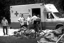
[76] The American Red Cross and the Salvation Army opened 48 shelters at the peak of need for people driven from their homes, which served nearly 300,000 meals.
[88] Due to the severe damage and deaths caused by the storm, the name Allison was retired from future use in the Atlantic basin in the spring of 2002 by the World Meteorological Organization.
Tropical storm (39–73 mph, 63–118 km/h)
Category 1 (74–95 mph, 119–153 km/h)
Category 2 (96–110 mph, 154–177 km/h)
Category 3 (111–129 mph, 178–208 km/h)
Category 4 (130–156 mph, 209–251 km/h)
Category 5 (≥157 mph, ≥252 km/h)
Unknown