Tropical Storm Candy
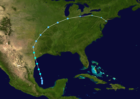
The storm reached its peak intensity of 70 mph (110 km/h) later that day and made landfall Port Aransas, Texas on June 23.
Due to rainfall from a trough for several days, combined 11 inches (280 mm) in some areas from Candy itself, flooding occurred in eastern Texas; there was minor damage to crops, roads, and bridges.
Between mid- to late June, satellite imagery indicated above normal amounts of shower and thunderstorm activity over the southwestern Gulf of Mexico.
[1] Later that afternoon, a United States Navy reconnaissance aircraft investigated the depression and recorded sustained winds of 50 mph (80 km/h) and a minimum barometric pressure of 1,001 mbar (29.6 inHg).
Despite moving ashore, Candy attained its peak intensity at 0000 UTC on June 24, with maximum sustained winds of 70 mph (110 km/h) and a minimum barometric pressure of 999 mbar (29.5 inHg).
While moving across the Midwestern United States, the storm began to lose tropical characteristics due to the presence of cold air.
However, damage from the storm surge was confined to the formation of "cuts" along Padre Island and to coastal oil refinery equipment.
Ten towboats and barges, as well as several other small vessels, received minor impacts at Hopper's Landing on San Antonio Bay.
[5] Outside of Texas, 2 to 4 inches (51 to 102 mm) of rain was reported in eastern Oklahoma, northwestern Arkansas, central Missouri, and northern Illinois.
Tropical storm (39–73 mph, 63–118 km/h)
Category 1 (74–95 mph, 119–153 km/h)
Category 2 (96–110 mph, 154–177 km/h)
Category 3 (111–129 mph, 178–208 km/h)
Category 4 (130–156 mph, 209–251 km/h)
Category 5 (≥157 mph, ≥252 km/h)
Unknown
