Tropical Storm Hermine (2010)
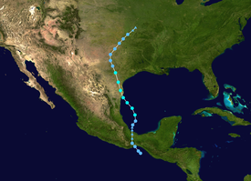
Though it was named in the western Gulf of Mexico, Hermine developed directly from the remnant low-pressure area associated with the short-lived Tropical Depression Eleven-E in the Eastern Pacific.
Though the depression quickly weakened to a remnant low, the disturbance crossed the Isthmus of Tehuantepec and tracked north into the warm waters of the Gulf of Mexico, where it reorganized into a tropical cyclone once again on September 5.
In the Eastern Pacific, Tropical Depression Eleven-E, along with moisture from a monsoonal flow, brought torrential rains to southern Mexico and Guatemala.
Further north, severe flooding affected large parts of Texas and Oklahoma, killing eight people and leaving at least $240 million in losses.
[2] However, the southern portion of the disturbance became disassociated with Danielle's development and tracked west into Northern South America, reaching the East Pacific on August 29.
[1] The cyclone's organized appearance on radar, which included a developing primordial eye, suggested that the depression was near tropical storm intensity at the time of landfall.
After moving inland, the depression quickly deteriorated and became a remnant low-pressure area by 18:00 UTC on September 4 over the Isthmus of Tehuantepec.
[1] Though the mountainous terrain of Oaxaca and Chiapas greatly disrupted Tropical Depression Eleven-E's organization and led to its demise, the former cyclone's mid- and lower-level circulations remained intact as they moved into the Bay of Campeche.
[1] Over the next day, the area of thunderstorms, initially disorganized,[7] coalesced into a tropical depression once again in the southern Bay of Campeche at 18:00 UTC on September 5.
Twelve hours after formation, the NHC upgraded the system to tropical storm status following conclusive reports from a nearby buoy.
[9] At 02:00 UTC on September 7, Hermine made landfall near Matamoros, Mexico with maximum sustained winds of 70 mph (110 km/h) and a minimum barometric pressure of 989 mbar (hPa; 29.21 inHg); this was the cyclone's peak intensity.
[11] By that time, the weakening storm had lost most of its tropical cyclone characteristics, with a long line of thunderstorms extending southwards and paralleling Interstate 35.
[12] Hermine was determined to have weakened to a remnant low-pressure area over Oklahoma at 18:00 UTC on September 9, before dissipating over Kansas on the next day.
[13] In Texas, the State Operations Center held a conference in relation to Tropical Storm Hermine to discuss emergency plans.
[16] As Hermine produced heavy rains from Texas to Missouri, the National Weather Service issued flash flood warnings for many areas.
[18] Across Guatemala, heavy rains associated with a monsoonal flow and Tropical Depression Eleven-E triggered numerous landslides across the country.
Along the Inter-American Highway, 41 people were killed after consecutive landslides buried a bus and rescue workers trying to pull survivors out of the trapped vehicle.
[21] Heavy impact was reported in southern Mexico, and several rivers overflowed their banks in the coast Oaxaca and thus a red (high) alert was issued.
[33] The strongest tornado struck Dallas just west of North Westmoreland Road near La Reunion Parkway, damaging several structures.
[37] After moving through Texas, the remnants of Hermine produced widespread rainfall, locally heavy, in Oklahoma which triggered significant flooding.
[40] In response to the substantial loss of life along Inter-American Highway, Guatemalan President Álvaro Colom declared a state of emergency for the country.
[19] As reports of widespread flooding came out of Texas, evacuation orders were issued for some of the hardest hit areas and seven shelters were opened in four counties.
[45] On October 12, governor Rick Perry filed a formal appeal to President Barack Obama to reconsider the denial of public assistance.
[45] On November 10, The U.S. Small Business Administration passed a disaster declaration for 18 counties in Texas, allowing residents to apply for low-interest loans.
Tropical storm (39–73 mph, 63–118 km/h)
Category 1 (74–95 mph, 119–153 km/h)
Category 2 (96–110 mph, 154–177 km/h)
Category 3 (111–129 mph, 178–208 km/h)
Category 4 (130–156 mph, 209–251 km/h)
Category 5 (≥157 mph, ≥252 km/h)
Unknown