Tropical Storm Fern
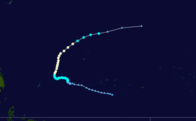
A tropical depression formed on December 21, when a low-level circulation center began to produce deep convection.
The depression strengthened into a tropical storm the next day, and was given the name Fern by the Joint Typhoon Warning Center (JTWC).
Fern peaked north of Yap on December 26, with JTWC assessing winds of 150 km/h (90 mph), while the Regional Specialized Meteorological Center, Japan Meteorological Agency (JMA) assessed peak winds of 110 km/h (70 mph), just below typhoon strength.
In the middle of December, twin monsoon troughs were established in the extreme western Pacific Ocean, which will later spawn storms Greg, and Fern itself in the northern hemisphere.
Two days later, convection consolidated near the circulation center,[1] and JMA began tracking it at 0000 UTC as a tropical depression.
[1][4] JMA proceeded to upgrade the depression into a tropical storm at 1800 UTC, with winds of 65 km/h (40 mph), and a pressure reading of 996 hectopascals (996 mbar).
[1][4] JMA assessed that Fern reached its peak of 110 km/h (70 mph), with a pressure reading of 975 hPa (975 mb) twelve hours later.
[2] Both warning centers downgraded Fern into a tropical depression by December 30, as it continued to travel along a shear line.
[4][6] At sea, a cargo ship en route from Guam to Yap was abandoned after it was damaged by high winds.
[1] Yap was directly hit by Fern on Christmas Day, causing about $3 million (1996 USD) of damage.
The Weather Service Office received a peak wind gust of 116 km/h (72 mph), and a pressure reading of 983 hPa (983 mbar).
Tropical storm (39–73 mph, 63–118 km/h)
Category 1 (74–95 mph, 119–153 km/h)
Category 2 (96–110 mph, 154–177 km/h)
Category 3 (111–129 mph, 178–208 km/h)
Category 4 (130–156 mph, 209–251 km/h)
Category 5 (≥157 mph, ≥252 km/h)
Unknown