Tropical Storm Hanna (2002)
Florida received high wind gusts, heavy rainfall, and strong surf that resulted in the deaths of three swimmers.
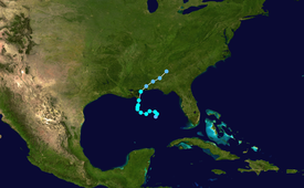
At the same time, a westward-moving tropical wave entered the gulf on September 10 and spawned a weak low along the trough, with little associated thunderstorm activity.
On September 11, an upper-level low over the United States moved into the Gulf and became cut off from the flow, allowing atmospheric convection to develop to the east of the tropical wave.
[1] After being designated, the cyclone became disorganized, and contained little deep and persistent convection; with dry air infringing on the western edge of the storm, substantial intensification was deemed unlikely.
[2] Despite being sheared, the cyclone neared tropical storm status later that day, though it remained a depression due to a partially non-tropical appearance.
[6] On September 14, the poorly organized cyclone crossed southeastern Louisiana, turned towards the north-northeast and made a second landfall close to the Alabama–Mississippi border at 1500 UTC that day, still at its peak strength.
The storm dissipated rapidly as it proceeded inland, and the remnant low pressure area moved into Georgia and South Carolina.
[1] After the landfall, officials issued flood watches for inland parts of Mississippi and Alabama as well as for western portions of Georgia and the Carolinas.
[7] On Dauphin Island in Alabama, some residents boarded up windows[8] and filled sandbags provided by local fire departments to prepare for Hanna.
Storm tides of 3.7 feet (1.1 m) caused minor coastal flooding and beach erosion in some areas, including along the causeway that crosses the Mobile Bay.
[1] The winds, combined with associated thunderstorms, caused minor damage, and brought down small trees and power lines.
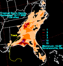
Although the heaviest rainfall was mostly confined to southwestern parts of the state,[18] precipitation was widespread within a northwest–northeast feeder band over central and northern Georgia.
[1] Due to the flooding and damage, Governor Roy Barnes declared Seminole, Miller and Decatur counties federal disaster areas.
[22] Various streams and ponds topped their banks, and flood waters on some roads reached an estimated 4 to 6 inches (100 to 150 mm) deep.
[25] Farther northward, the remnants of Tropical Storm Hanna contributed to around 1 inch (25 mm) of rainfall in New England, particularly in Vermont.
Tropical storm (39–73 mph, 63–118 km/h)
Category 1 (74–95 mph, 119–153 km/h)
Category 2 (96–110 mph, 154–177 km/h)
Category 3 (111–129 mph, 178–208 km/h)
Category 4 (130–156 mph, 209–251 km/h)
Category 5 (≥157 mph, ≥252 km/h)
Unknown