Hurricane Diana
The fourth named storm and second hurricane of the season, Diana developed from a tropical wave in the southwestern Caribbean on August 4.
Continuing to gradually strengthen, Diana made its first landfall in Mexico's Yucatán Peninsula as a strong tropical storm late on August 5.
Some locations observed tropical storm-force sustained winds and gusts, while heavy rains left street flooding in the Chetumal area.
Hurricane Diana originated from a tropical wave which emerged into the Atlantic Ocean from the west coast of Africa on July 27.
Unfavorable conditions initially prohibited tropical cyclogenesis, with the wave remaining disorganized until reaching the eastern Caribbean Sea.
The system entered the Caribbean Sea through the southern Windward Islands, where barometric pressures fell slightly, decreasing by 3.5 mbar (hPa; 0.1 inHg) in 24 hours.
After satellite imagery observed a cyclonic rotation in the low-level convection, the fifth tropical depression of the season developed over the Caribbean around 00:00 UTC on August 4, while located about 125 mi (200 km) east of Isla de Providencia.
However, this was based on surface observations, and the formation of a tropical cyclone operationally remained unconfirmed until another reconnaissance aircraft flight later that day.
Around 00:00 UTC on August 5, about 24 hours after developing, the cyclone intensified into a tropical storm while offshore northeastern Honduras; the National Hurricane Center assigned the name Diana to the system.
Diana would subsequently strengthen further, with winds reaching 65 mph (105 km/h) before the storm made landfall near Felipe Carrillo Puerto, Quintana Roo, around 20:00 UTC later that day.
Upon entering the Bay of Campeche, Diana began moving nearly due west as a result of a weakening trough of low pressure.
Twelve hours later, the cyclone intensified into a Category 2 hurricane and attained its peak intensity with maximum sustained winds of 100 mph (160 km/h) and a minimum barometric pressure of 980 mbar (hPa; 28.94 inHg).
[1] Moving inland, Diana rapidly weakened over the high terrain of Mexico, quickly deteriorating from a low-end Category 2 hurricane to a strong tropical storm by 00:00 UTC on August 8.
[3] Civil defense officials in Quintana Roo recommended that residents in coastal areas and in homes with weak construction to evacuate.
The Mexican Coast Guard was placed on alert and shipping activity around Quintana Roo ceased during the evening of August 5,[4] as tides were expected to range from 3 to 5 ft (0.91 to 1.52 m) above normal.
[5] Additionally, officials expressed concerns about flash flooding due to the possibility of 5 to 8 in (130 to 200 mm) of rainfall in areas near the storm's path.
[3] The National Hurricane Center also predicted precipitation totals of 8 in (200 mm) and emphasized that flash floods and mudslides would likely occurred in the vicinity of where Diana was projected to make landfall.
[7] State and federal officials prepared 10,000 packages of emergency supplies, food, and medicine and moved them to several locations along the coast.
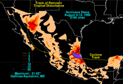
[19] The San Juan River overflowed in the town of Huejutla de Reyes, sweeping away hundreds of homes and some people in one neighborhood.
[23] The remnants of Hurricane Diana eventually moved into the Southwestern United States, bringing heavy rainfall to the region.
In Apache Junction, police and city officials rushed to close flooded streets, including portions of state highways and underpasses of Interstate 17.

Tropical storm (39–73 mph, 63–118 km/h)
Category 1 (74–95 mph, 119–153 km/h)
Category 2 (96–110 mph, 154–177 km/h)
Category 3 (111–129 mph, 178–208 km/h)
Category 4 (130–156 mph, 209–251 km/h)
Category 5 (≥157 mph, ≥252 km/h)
Unknown