Tropical Storm Mujigae
The disturbance organized to a tropical depression and was assigned the names 14W by the Joint Typhoon Warning Center and Maring by PAGASA later that day.
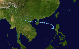
Early on 8 September 2009, the Joint Typhoon Warning Center reported that an area of convection had persisted about 340 km (210 mi) northwest of Manila in the Philippines.
[1] The disturbance had a broad low-level circulation center with convection starting to consolidate and was developing along the monsoon trough in favorable conditions.
[2][3] The next morning, the JTWC designated the tropical depression as 14W after the system had rapidly consolidated with deep convective bands forming in the low-level circulation center.
[16][17] PAGASA also warned residents living in low-lying areas and near mountain slopes to take all the necessary precautions against possible flash floods and landslides.
In Pampanga, the NDCC placed the towns of Santa Ana, San Luis, Minalin, Mexico, Macabebe, Masantol, Apalit, Guagua, Sasmuan, Lubao, and Bacolor in state of calamity due to swelling rivers in Tarlac.
More than 300,000 residents of four northern provinces were affected by floods, including about 3,300 people who fled to evacuation centers and more than 41,000 who moved in with their relatives and friends.
Flights at the Meilan Airport in the province's capital of Haikou were suspended on Thursday afternoon because of strong winds and heavy rains.
Tropical storm (39–73 mph, 63–118 km/h)
Category 1 (74–95 mph, 119–153 km/h)
Category 2 (96–110 mph, 154–177 km/h)
Category 3 (111–129 mph, 178–208 km/h)
Category 4 (130–156 mph, 209–251 km/h)
Category 5 (≥157 mph, ≥252 km/h)
Unknown