Typhoon Chan-hom (2009)
Moving towards the northeast, it slowly organized according to JTWC who issued a TCFA, and JMA classified Chan-hom as a minor tropical depression later that day.
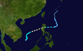
Typhoon Chan-hom was first identified as a disorganized area of low pressure on May 2, 2009 situated roughly 305 km (190 mi) southeast of Nha Trang, Vietnam in the South China Sea.
Deep convection was mainly confined to the northern portion of the system; however, a band of cloud cover had begun to wrap around the center of circulation during the afternoon.
Further development was anticipated as the storm slowly moved through an area of warm sea surface temperatures and low wind shear, conditions favoring tropical cyclone formation.
[4] Following the formation of a central dense overcast,[5] both the JTWC and JMA upgraded the depression to a tropical storm, at which time it received the name Chan-hom.
[5] According to the JMA, maximum sustained winds within the cyclone had reached 95 km/h (59 mph), prompting the agency to upgrade Chan-hom to a severe tropical storm.
[5] In light of this information, the JTWC assessed Chan-hom to have reached its peak intensity at this time, packing sustained winds of 160 km/h (99 mph) and an estimated barometric pressure of 956 mbar (hPa; 28.23 inHg).
Although wind shear remained at unfavorably high levels,[5] Chan-hom maintained tropical storm intensity through its crossing of Luzon through the end of May 8.
With the addition of dry air entering the system, the storm was not expected to regain strength as it began to take a northward turn.
[4] The JMA and JTWC continued to monitor the remnants of Chan-hom through May 13, at which time its low-level circulation collapsed to the southeast of Okinawa, Japan.
As Chan-hom formed in the South China Sea Vietnamese officials warned 17,793 vessels, with a total of 83,032 fishermen on board the ships, to avoid areas near the tropical storm.
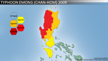
President Arroyo instructed the National Disaster Coordinating Council (NDCC) to provide public hourly updates on the entry of typhoon Emong.
Rain was also heavy over Pampanga (receiving 145 mm), Nueva Ecija, Tarlac, Bulacan, Bataan, Metro Manila and parts of southern Luzon.
In the town of Anda in Pangasinan, 90 percent of houses had their roofs blown away, with mango trees uprooted and cultured fishes washed away to the sea.
The Department of Social Welfare and Development reported that PHP 2.7 million (US$57,000) worth of relief supplies was stockpiled and ready for distribution.
Tropical storm (39–73 mph, 63–118 km/h)
Category 1 (74–95 mph, 119–153 km/h)
Category 2 (96–110 mph, 154–177 km/h)
Category 3 (111–129 mph, 178–208 km/h)
Category 4 (130–156 mph, 209–251 km/h)
Category 5 (≥157 mph, ≥252 km/h)
Unknown