Tropical Storm Trudy (2014)
Trudy ultimately achieved its peak intensity as a strong tropical storm with 65 mph (100 km/h) winds as it made landfall just southeast of Marquelia, Mexico.
On October 8, a weak area of low pressure developed within a monsoon trough over the extreme eastern edge of the Pacific basin.
[3] The National Hurricane Center (NHC) began monitoring the system for long-term cyclogenesis on October 13, at which time the low was situated 150 mi (240 km) south of Guatemala.
[4] Organization was prolonged and slow;[5] however, the convergence of a Kelvin wave and a Gulf of Tehuantepec gap wind event on October 15 spurred a significant increase in convection.
[6] Marked structural improvements took place on October 17 and the NHC assessed a high probability of the system becoming a tropical cyclone within 48 hours.
[6] With the cyclone located over warm waters of 86 °F (30 °C) and within a very moist region with low wind shear, intensification was a certainty as the depression approached Mexico.
[8] Owing to the aforementioned environmental conditions, the depression intensified to a tropical storm by 18:00 UTC on October 17;[6] it was subsequently assigned the name Trudy by the NHC.
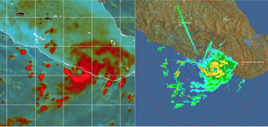
[9] During the morning of October 18, a central dense overcast became increasingly defined; microwave satellite imagery and coastal radars depicted the formation of a 12 to 17 mi (19 to 27 km) wide eye by 03:00 UTC.
[6][10] It is estimated that Trudy reached its peak intensity around 09:15 UTC on October 18 with maximum sustained winds of 65 mph (100 km/h) and a barometric pressure of 998 mbar (hPa; 29.47 inHg).
Forecasters at the NHC noted that the greatest threat from the system would be torrential rains across Guerrero and Oaxaca that could trigger life-threatening flash floods and mudslides.
[12] Rapid organization of the system prompted a hurricane watch to be issued by 09:00 UTC on October 18 for areas between Acapulco and Lagunas de Chacahua.

Tropical storm (39–73 mph, 63–118 km/h)
Category 1 (74–95 mph, 119–153 km/h)
Category 2 (96–110 mph, 154–177 km/h)
Category 3 (111–129 mph, 178–208 km/h)
Category 4 (130–156 mph, 209–251 km/h)
Category 5 (≥157 mph, ≥252 km/h)
Unknown