Tundra orbit
The Molniya orbit was specifically designed in the 1960s to provide better communication coverage for high-latitude regions, which geostationary satellites struggled to cover effectively.
The Tundra orbit, while similar in its high inclination and elliptical shape, was developed later to offer continuous coverage over specific areas by having satellites spend most of their time over a chosen region.
Both orbits were innovative solutions to the unique challenges posed by the Soviet Union's geographical location and the need for reliable communication and surveillance capabilities.
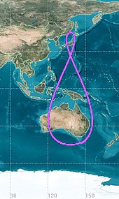
The ground track of a satellite in a Tundra orbit is a closed figure 8 with a smaller loop over either the northern or southern hemisphere.
This is desirable as broadcasting to these latitudes from a geostationary orbit (above the Earth's equator) requires considerable power due to the low elevation angles, and the extra distance and atmospheric attenuation that comes with it.
Sites located above 81° latitude are unable to view geocentric satellites at all, and as a rule of thumb, elevation angles of less than 10° can cause problems, depending on the communications frequency.
[5]: 499 [6] Highly elliptical orbits provide an alternative to geostationary ones, as they remain over their desired high-latitude regions for long periods of time at the apogee.
These changes are less pronounced for satellites in a Tundra orbit, given their increased distance from the surface, making tracking and communication more efficient.
[3] A typical[7] Tundra orbit has the following properties: In general, the oblateness of the Earth perturbs a satellite's argument of perigee (
An argument of perigee of 0° or 180° would cause the satellite to dwell over the equator, but there would be little point to this as this could be better done with a conventional geostationary orbit.
[7] The eccentricity is chosen for the dwell time required, and changes the shape of the ground track.
The constellation was developed to better reach consumers in far northern latitudes, reduce the impact of urban canyons and required only 130 repeaters compared to 800 for a geostationary system.
After Sirius' merger with XM it changed the design and orbit of the FM-6 replacement satellite from a tundra to a geostationary one.
[14][15] This supplemented the already geostationary FM-5 (launched 2009),[16] and in 2016 Sirius discontinued broadcasting from tundra orbits.
[21] The Tundra orbit has been considered for use by the ESA's Archimedes project, a broadcasting system proposed in the 1990s.