Typhoon Bolaven (2012)
On August 24, the system attained its peak intensity, with winds of 185 km/h (115 mph)[nb 1] and a barometric pressure of 910 mbar (hPa; 26.87 inHg).
Steady weakening continued as Bolaven approached the Korean Peninsula and it eventually made landfall in North Korea late on August 28 before transitioning into an extratropical cyclone.
The remnants rapidly tracked northeastward over the Russian Far East before turning eastward and were last noted on September 1 crossing the International Dateline.
Tracking slowly northeastward into a region of warm sea surface temperatures, low wind shear, and favorable divergence, continued development was anticipated.
[3][4] Later on August 19, the Joint Typhoon Warning Center (JTWC)[nb 2] issued a Tropical Cyclone Formation Alert as the system was anticipated to develop further.
[8] Following the development of convective banding features along the southern side of the low, both the JMA and JTWC upgraded the depression to a tropical storm, with the former assigning it the name Bolaven.
[12] Throughout the day, a large central dense overcast developed around the low-level circulation and banding features became more prominent, especially over the southern half of the storm.
However, the northwestern quadrant of Bolaven struggled to organize as quickly due to moderate wind shear produced by a nearby upper-level anticyclone.
[16] Although subsidence and wind shear increased along the northern edge of the storm on August 23, the system's outflow allowed it to mitigate the negative effects ahead of it.
[18] During this brief turn, the center of Bolaven crossed 135°E, entering the area of responsibility of the Philippine Atmospheric, Geophysical and Astronomical Services Administration (PAGASA).
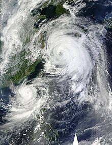
[19] Later that day, a well-defined, 18 km (11 mi) wide eye developed within the central dense overcast and several additional feeder bands formed along the south side of the circulation.
Based on the improved structure, the JTWC estimated that the system attained one-minute sustained winds of 215 km/h (135 mph), equivalent to a Category 4 on the Saffir–Simpson Hurricane Scale.
At that time, the JMA estimated the typhoon to have reached its peak intensity with winds of 185 km/h (115 mph) and a barometric pressure of 910 mbar (hPa; 26.87 inHg).
[32] Increasing shear started taking its toll early on August 28 as convection became displaced from the center of circulation, leaving part of the southwestern quadrant exposed.
[37] The JMA continued to monitor Bolaven as a tropical cyclone until early on August 29, at which time the system was situated over the southern region of the Russian Far East.
[39] On August 24, fishing vessels and small craft off the northern and eastern coasts of Luzon, Philippines, were advised to not venture out due to large swells produced by Typhoons Bolaven and Tembin.
[40] On August 22, hours before the JTWC classified Bolaven as a typhoon, Okinawa was placed under Tropical Cyclone Condition of Readiness (TCCR) four.
At this time, the then Category 4-equivalent typhoon was expected to pass directly over Okinawa and based on forecasts from the JTWC, it would be the most powerful storm to hit the island in 13 years.
[47] Transportation across the island was paralyzed due to the storm as ferry terminals, airports, and bus and rail services were shut down.
[49] The slow motion of the storm led meteorologists at the JMA to warn residents of a potential record rainfall event, stating that localized areas could receive between 400 and 600 mm (16 and 24 in) of rain.
[50][51] Due to the significant threat of flash flooding and mudslides, residents living in flood-prone or mountainous areas were urged to evacuate.
[57] Numerous ports banned sea travel and shut down activities by August 27, and 68 of the nation's 87 ferry routes were canceled.
[59] Storm warnings were issued as far north as the Russian Far East as officials anticipated the remnants of the typhoon to cause significant disruption in the region.
[65] Although the storm was expected to cause significant disruptions in the region, Russian Emergencies Minister Vladimir Puchkov stated that the Asia-Pacific Economic Cooperation Summit in Vladivostok would continue as planned.
[76] During the height of the storm, the highest level of warning, TCCR 1-E (emergency), was issued for the island, indicating that all outdoor activities were banned.
[98] About 2 km (1.2 mi) off the coast of Jeju Island, two Chinese vessels with a total of 33 people aboard, sank during the storm on August 28.
[110] Gale-force winds prompted the temporary closure of the Bridge to Russky Island, which was built specifically for the Asia-Pacific Economic Cooperation Summit.
[115] On September 11, the Food, Agriculture, Forestry and Fisheries Minister announced that residents severely affected by the typhoon were eligible for up to ₩50 million (US$44,000) in construction assistance.
[117] On September 4, Hwang Woo-yea, chairman of South Korea's Saenuri Party, urged the government to seek international aid, namely in the form of food, for North Korean residents affected by the typhoon.
[118] On September 6, the Red Cross Society of Democratic People's Republic of Korea announced that international aid may be requested for the effects of severe flooding in July and Typhoon Bolaven.

Tropical storm (39–73 mph, 63–118 km/h)
Category 1 (74–95 mph, 119–153 km/h)
Category 2 (96–110 mph, 154–177 km/h)
Category 3 (111–129 mph, 178–208 km/h)
Category 4 (130–156 mph, 209–251 km/h)
Category 5 (≥157 mph, ≥252 km/h)
Unknown