Typhoon Tembin (2012)
[1] On August 17, the Japan Meteorological Agency (JMA) mentioned it as a tropical depression, as a subtropical ridge pushed the system southwards.
[6] On August 20, Tembin entered a period of explosive intensification, on encountering warm and deep Oceanic heat content.
[7] Only 3 hours later, the JTWC pointed out that an eye of radius 20 nautical miles (37 km; 23 mi) has formed under the low-level circulation center (LLCC) and is being powered by a self-induced meso-anticyclone.
A building western extension of a ridge close to the equator started showing a steering effect on the system, at that time.
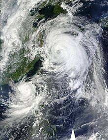
The system maintained deep convective banding, tightly wrapped into a well-defined, small 10 nautical miles (19 km; 12 mi) eye surrounded by a highly symmetric eyewall.
At that time, Tembin was tracking north-northwestward at 08 knots (15 km/h; 9.2 mph) and was located approximately 280 nautical miles (520 km; 320 mi) southeast of Taipei, Taiwan.
Located approximately 255 nautical miles (472 km; 293 mi) southeast of Taipei, the system tracked north-northwestward at 05 knots (9.3 km/h; 5.8 mph) during the past six hours.
Animated enhanced infrared satellite imagery showed that the system maintained overall tight consolidation and symmetry even as poleward outflow had slightly diminished.
Upper level analysis indicated that Tembin sustained a mesoscale anticyclone that continues to provide good outflow despite two TUTT cells, one to the north and one to the southwest of the typhoon causing subsidence and strong shear along the west to southwestern flank.
[14] On the morning on August 22, Animated multispectral satellite imagery showed that the central convection has slightly warmed as the overall structure became more elongated, an indication of increased shear.
Located approximately 210 nautical miles (390 km; 240 mi) southeast of Taipei, the storm system became a little less organized over the past couple of hours.
[17] Track speeds continued to be slow as a primary steering influence, a deep layered subtropical ridge to the storm's north, was being weakened by a transiting mid-latitude trough located over the Korean Peninsula.
Upper-level analysis indicated that the poleward outflow towards the tropical upper-tropospheric trough cell that was located over southern honshu shut down.
Upper level analysis indicated that the dual channel outflow to the poleward and equatorward directions had been instrumental in the system maintaining its intensity.
Located approximately 180 nautical miles (330 km; 210 mi) south-southwest of Taipei, the storm system was drifting west-southwestward at nearly 10 knots (19 km/h; 12 mph).
[23] Later that morning, animated multispectral satellite imagery depicted that the structure of the low level circulation center suffered a significant inflow issue as winds along the southeastern quadrant tracked over southern Taiwan.
Upper level analysis indicated a weak point source anticyclone that continued providing good outflow and low vertical wind shear environment.
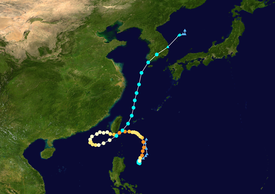
After developing an eye, Tembin rapidly intensified into a category 3 typhoon, before gradually weakening due to an easterly wind shear from Bolaven, which caused the LLCC to become slightly exposed, associated with a few burst of convection, and made its closest approach to Taiwan on 17:30(UTC) as a tropical storm.
[26][27][28] Early on August 28, Tembin entered the East China Sea, after making a circle back toward Taiwan as a tropical storm.
[31] On August 21, the Central Weather Bureau in Taiwan issued a sea warning for Typhoon Tembin, predicting strong winds, heavy rains and storm surge.
[32] By August 22, the Ministry of National Defense of Taiwan helped evacuate several residents in the typhoon-prone areas and provided accommodation to some in their own military camps.
Authorities in Pingtung reported that the town of Hengchun was hit by heavy flooding, with waters reaching 3 m (9.8 ft) high in some places.
Tropical storm (39–73 mph, 63–118 km/h)
Category 1 (74–95 mph, 119–153 km/h)
Category 2 (96–110 mph, 154–177 km/h)
Category 3 (111–129 mph, 178–208 km/h)
Category 4 (130–156 mph, 209–251 km/h)
Category 5 (≥157 mph, ≥252 km/h)
Unknown