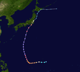
Typhoon Ida (1958)
Two days later, the Hurricane Hunters observed a minimum barometric pressure of 877 mb (25.9 inHg), as well as estimated peak winds of 325 km/h (202 mph).
This made Ida the strongest tropical cyclone on record at the time, although it was surpassed by Typhoon June 17 years later.
Ida weakened as it continued to the north-northeast, and made landfall in Japan on southeastern Honshū with winds of 130 km/h (80 mph) on September 26.
[2] Around that time, the Hurricane Hunters reported that the eye was obscured, and over the subsequent 24 hours the eyewall remained incomplete.
However, over a 14-hour period beginning at 15:00 UTC on September 23, Typhoon Ida began undergoing rapid deepening, at times a rate of 5.8 mbar (0.17 inHg) per hour.
The eye became increasingly well-defined,[3] and near 05:00 UTC on September 24, a reconnaissance aircraft deployed a dropsonde in the typhoon about 600 mi (970 km) northwest of Guam.
[9] While Typhoon Ida was striking Japan, it produced heavy rainfall that reached 748.6 mm (29.47 in) on Mount Amagi on the Izu Peninsula.
[10] In the capital city of Tokyo, the storm dropped almost 430 mm (17 in) of rainfall, which was the highest daily total since record-keeping began in 1876.
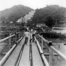
In the Tokyo area, the storm caused widespread power outages and severely disrupted the transportation system.
Tropical storm (39–73 mph, 63–118 km/h)
Category 1 (74–95 mph, 119–153 km/h)
Category 2 (96–110 mph, 154–177 km/h)
Category 3 (111–129 mph, 178–208 km/h)
Category 4 (130–156 mph, 209–251 km/h)
Category 5 (≥157 mph, ≥252 km/h)
Unknown