Typhoon Jelawat (2018)
Upon shifting northeast, Jelawat rapidly intensified on March 30 due to low vertical wind shear and substantial outflow, peaking as a Category 4-equivalent super typhoon.
Shortly afterward, the storm began to weaken as wind shear sharply increased, falling below typhoon strength on March 31.
[9] Throughout March 26, moderate wind shear displaced disorganized and fragmented convection to the north of the circulation, hindering the storm's ability to organize.
[10] At 00:00 UTC of March 27, the system crossed the eastern boundary of the area of warning responsibility of the Philippine Atmospheric, Geophysical, and Astronomical Services Administration, prompting the agency to assign the local name Caloy.
[11] Convection strengthened over the northwest quadrant of the fully-exposed center; vertical wind shear was subdued by outflow, allowing for additional intensification.
[13] Tracking towards a region of favorable wind shear,[14] Jelawat moved north along the 135°E boundary of the Philippine Area of Responsibility, before exiting early March 28.
[19] Jelawat continued to stockpile convection within the formative eye while also maintaining substantial poleward outflow boosted by a subtropical westerly jet; accordingly, the JTWC classified the storm as a typhoon.
[20] Drifting northeastward in favorable conditions on March 30, the storm underwent explosive intensification, and exhibited a sharp 19-kilometer-wide (12 mi) eye surrounded by symmetric deep convection.
[21] By 12:00 UTC, Jelawat attained its peak intensity, with 10-minute maximum sustained winds of 195 km/h (120 mph) and the lowest barometric pressure of 915 hPa (27.02 inHg) assessed by the JMA.
[22][nb 3] The eye had shrunk by almost half its initial size, and despite the conducive conditions, Jelawat was approaching an area of high vertical wind shear associated with the subtropical jet.
[6] While passing north of Pagan on April 1, the ragged circulation interacted with the baroclinic zone and began possessing frontal characteristics.
Eleven bridges and culverts were damaged, and throughout the events, a landslide warning and six flood statements were announced by the island's local Weather Service Office.
[38] Jelawat poured 149 mm (5.87 in) of rain over Yap as the system passed to the south throughout March 24–29, keeping the island chain under the influence of its outer rainbands.
[41] A tropical storm warning was then issued for Agrihan and Pagan on April 1, as it was forecasted that Jelawat would pass 40 km (25 mi) north of the former,[42] though they were canceled later that day.
[43] The high surf advisories across the archipelago were lifted, as Jelawat was rapidly weakening from vertical wind shear, and no longer posed a threat towards the islands.
[47] Additionally, Jelawat induced a surge of Indo-Pacific man-of-war sightings across the east and west coasts of Guam, though no one was reported to have been stung by them.
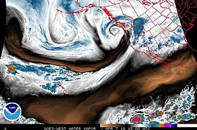
[48] Around early April, Jelawat's remnants entered an atmospheric river originating from Hawaii, dubbed a Pineapple Express, after its moist core flowed into the western end of the channel, reaching California;[49] the moisture was entrained in and maintained by an Aleutian low.
Another incident in Highway 4 was reported when a truck spun out on eastbound at Port Chicago, closing three lanes of traffic and entangling the East Bay freeway.
In Grizzly Peak Boulevard, an emergency crew was called when a car fell 30 m (100 ft) off an embankment; their efforts were hindered by fog alongside rain and wind.

Tropical storm (39–73 mph, 63–118 km/h)
Category 1 (74–95 mph, 119–153 km/h)
Category 2 (96–110 mph, 154–177 km/h)
Category 3 (111–129 mph, 178–208 km/h)
Category 4 (130–156 mph, 209–251 km/h)
Category 5 (≥157 mph, ≥252 km/h)
Unknown