Typhoon Dolphin (2015)
The seventh named storm of the 2015 Pacific typhoon season, Dolphin formed on May 6 in the vicinity of the Federated States of Micronesia (FSM).
The rains and gusty winds knocked down many trees on the island, one of which killed a person, and causing $1 million in damage (2015 USD).
The origins of Dolphin were related to a strong westerly wind burst that also led to the formation of previous Typhoon Noul.
[1] Early on May 5, the Joint Typhoon Warning Center (JTWC) began monitoring an area of deep convection approximately 300 km (190 mi) southwest of Pohnpei.
It had a poorly-defined circulation and broad rainbands, while low to moderate wind shear and warm sea surface temperatures favored development.
[3] The Japan Meteorological Agency (JMA) classified the system as a tropical depression at 06:00 UTC on May 6 about 325 km (202 mi) southwest of Pohnpei.
[4] At 21:00 UTC that day, the Joint Typhoon Warning Center (JTWC) also began issuing advisories on the system, classifying it as Tropical Depression 07W.
[6] Wind shear in the region exposed the convection from the circulation early on May 7,[7] although the thunderstorms increased the next day, mostly in the storm's northwest quadrant.
[4] By that time, the system had developed rainbands spiraling around the circulation,[9] although continued wind shear left the center exposed.
[16] The intensification trend was soon halted by a combination of moderate southerly wind shear and dry air from the west, causing the eye to become obscured on conventional satellite imagery.
[1] After leaving the Marianas Islands, the eye of Dolphin became much larger as the storm developed strong outflow channels, both indicative of further strengthening.
[4] Based on the well-defined structure and Dvorak ratings of T7.0, the JTWC upgraded Dolphin to a super typhoon late on May 16 with 1 minute winds of 260 km/h (160 mph).
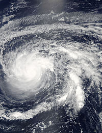
[22] The approaching westerlies turned Dolphin to the north and northeast on May 17 while also imparting unfavorable conditions, causing the eye and the convection to elongate and weaken.
[26] The typhoon's westerly winds produced a swell that affected the Marshall Islands, sinking several boats in Kwajalein Atoll.
[27] The Federal Emergency Management Agency (FEMA) deployed approximately 15 representatives to the island to mitigate the response time in the wake of the storm.
High winds left about 40% of Guam without power, mostly in the north and central portions of the island,[33] although the outages were fixed within a few days.
Rough waves sank a boat at Apra Harbor, requiring workers to clean oil that escaped from the damaged vessel.
On June 5, President Barack Obama signed a major disaster declaration for the territory, allowing for federal aid to be used.
[45] The remnants of Dolphin, in conjunction with previous Typhoon Noul, shifted the broader weather pattern to bring record warmth to Alaska, making the temperatures warmer than that of Washington, D.C.[46]

Tropical storm (39–73 mph, 63–118 km/h)
Category 1 (74–95 mph, 119–153 km/h)
Category 2 (96–110 mph, 154–177 km/h)
Category 3 (111–129 mph, 178–208 km/h)
Category 4 (130–156 mph, 209–251 km/h)
Category 5 (≥157 mph, ≥252 km/h)
Unknown