Hurricane Hector (2018)
A favorable environment allowed the fledgling tropical storm to rapidly intensify to its initial peak as a Category 2 hurricane by 18:00 UTC on August 2.
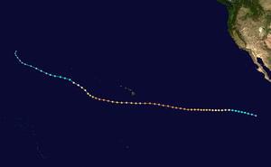
Hector's precursor began producing convection while traveling westward over northern South America, entering the Eastern Pacific basin by July 25.
[5] Located within a favorable environment fueled by a kelvin wave and the Madden–Julian oscillation,[1] the disturbance gradually became more organized over the next five days as it continued generally westward.
[6] The system developed into Tropical Depression Ten-E around 12:00 UTC on July 31 while about 805 mi (1,296 km) south-southwest of the southern tip of the Baja California Peninsula.
Initially, the depression was irregularly shaped and its circulation elongated,[7] but it steadily improved in organization over the next 12 hours, becoming Tropical Storm Hector at 00:00 UTC on August 1.
[1][8] After strengthening into a tropical storm, Hector remained disorganized for several hours as a result of increasing easterly wind shear, with most of its convection displaced to the south and west.
[10][11] Over the next several hours, Hector significantly improved in organization, with its low-level center becoming markedly embedded within the deep convection and the development of a mid-level eye.
[1][13] Six hours later, the storm reached its initial peak intensity as a Category 2 hurricane with maximum sustained winds of 105 mph (169 km/h) and a minimum central pressure of 975 mbar (28.79 inHg).
[1] Hector began to strengthen a short time later as it traversed an area of slightly cooler sea temperatures, low wind shear, and elevated mid-level moisture.
[16] Hector became a Category 3 major hurricane around 00:00 UTC on August 4, while located approximately 1,680 mi (2,700 km) west-southwest of the southern tip of Baja California.
[20] Hector began to move slightly north of west due to a weakness in a subtropical ridge located to the northeast of the Hawaiian Islands.
[21] About six hours later, a 53rd Weather Reconnaissance Squadron plane recorded a stepped frequency microwave radiometer (SFMR) wind speed of 158 mph (254 km/h) as it surveyed the cyclone.
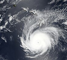
Hector reached its peak intensity with maximum sustained winds of 155 mph (249 km/h) and a minimum central pressure of 936 mbar (27.64 inHg) around 18:00 UTC.
[23] As Hector approached Hawaii, its weakening trend continued due to mid-level dry air, low ocean heat content, and 81 °F (27 °C) sea surface temperatures.
Although forecasts depicted Hector remaining south of Hawaii, concerns were raised over the safety of residents displaced by the ongoing eruption of Kīlauea, many of whom were in temporary tent structures that could not withstand a hurricane.
[26] Overall, the impact to Hawaii was minimal; peak 2-minute sustained winds of 25 mph (40 km/h) were recorded in South Point on the Big Island and 0.17 in (4.3 mm) of rain registered at Hilo International Airport.
[32] After passing by Hawaii, Hector began another period of strengthening on August 9 as it moved across a region of slightly warmer sea surface temperatures and higher ocean heat content.
[1][35] Hector began to weaken once more as an upper-level low located just east of the International Date Line imparted southerly shear and caused the cyclone to take on a more northwesterly track.
[39] Later in the day, Hector's low-level center became displaced to the south of its thunderstorm activity as strong wind shear continued to bombard the system.
[1] Convection associated with Hector began to dissipate on August 13, leaving the low-level center uncovered; all that remained were regions of cirrus clouds.
[41] Hector crossed into the western Pacific Ocean shortly after 15:00 UTC on August 13 as a weakening tropical storm,[1] entering the Japan Meteorological Agency's (JMA) area of responsibility.
Tropical storm (39–73 mph, 63–118 km/h)
Category 1 (74–95 mph, 119–153 km/h)
Category 2 (96–110 mph, 154–177 km/h)
Category 3 (111–129 mph, 178–208 km/h)
Category 4 (130–156 mph, 209–251 km/h)
Category 5 (≥157 mph, ≥252 km/h)
Unknown