Typhoon Koinu
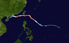
Koinu originated from an area of low pressure near Guam that generally moved westward into the Philippine Sea, where it was upgraded into a depression.
On September 27, a low-pressure area formed near Guam, with the JTWC indicating the potential development of a tropical cyclone.
Koinu moved west northwestward in the Philippine Sea whilst having its low-level circulation exposed due to wind shear.
Koinu then began a period of rapid intensification by the evening of October 1 into the early morning hours, intensifying to become a low-end Category 4 typhoon whilst it developed a clear eye as it moved east of Cagayan before weakening slightly.
Koinu passed dangerously close to Lanyu, and making its first landfall on mainland Hengchun, Taiwan, later weakening into a Category 3 storm as it did so.
[3] Contrary to forecasts, Koinu unexpectedly restrengthened back into a Category 2, reforming a clear visible eye surrounded by a powerful eyewall.
Dry air intrusion and land interaction continued to weaken the system into a tropical storm on October 9.
[4] As Jenny moved further away and weakened, the rains and winds started to subside, however, locals were still warned that the storm may still trigger moderate to rough seas in the areas affected.
[5] Taiwanese authorities issued weather warnings in preparation of strong gusts and heavy rain hitting the island's southeast.
While the storm is likely to bring the most rain to hilly and sparsely inhabited areas, it will also affect the large port city of Kaohsiung.
Tropical storm (39–73 mph, 63–118 km/h)
Category 1 (74–95 mph, 119–153 km/h)
Category 2 (96–110 mph, 154–177 km/h)
Category 3 (111–129 mph, 178–208 km/h)
Category 4 (130–156 mph, 209–251 km/h)
Category 5 (≥157 mph, ≥252 km/h)
Unknown