Typhoon Mitag (2019)
Tracking generally northwestward, the system gradually organised and the Japanese Meteorological Agency issued its first advisory on Tropical Depression 19W on September 27.
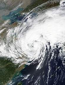
Mitag, while gaining latitude, strengthened quickly on September 29 and within just hours became a severe tropical storm,[3] and shortly after, a category 1 typhoon later on that same day.
[10] Shortly after land interaction with South Korea, its low-level circulation center was continually exposed by westerly wind shear and its cloud tops became displaced, leading to it weakening below tropical depression status on October 3 and becoming extratropical the next day.
[11] As Mitag was initially forecast to come near the Philippines, a Signal 1 warning was raised for a portion of Luzon and the Batanes and the Babuyan Islands as the storm passed just northeast of the country as a category 1 typhoon.
[12] As forecast, the storm's outer bands produced heavy rainfall, rough sea conditions, and gusty winds in Northern Luzon, but no damage was reported.

Tropical storm (39–73 mph, 63–118 km/h)
Category 1 (74–95 mph, 119–153 km/h)
Category 2 (96–110 mph, 154–177 km/h)
Category 3 (111–129 mph, 178–208 km/h)
Category 4 (130–156 mph, 209–251 km/h)
Category 5 (≥157 mph, ≥252 km/h)
Unknown