Typhoon Omar
In response to the destruction, the island's building codes were updated to withstand winds of 250 km/h (155 mph), and insurance companies discontinued new policies for structures not made of concrete.
Typhoon Omar originated from a tropical disturbance that was first noted on August 20 over the open Pacific Ocean, which exhibited persistent convection, or thunderstorms.
[2] As the depression traveled generally westward, the JTWC upgraded it to Tropical Storm Omar on August 25,[2] and the JMA followed suit on the next day.
Outflow from nearby Tropical Storm Polly to the west produced a stream of strong wind shear over Omar, slowing intensification.
[2] The eye, 37 km (23 mi) in diameter,[2] slowly crossed the northern portion of the small island over a period of 2.5 hours.
[1] By 1500 UTC on September 3, the JMA downgraded Omar to a tropical storm,[4] although the JTWC maintained its typhoon intensity through the next day.
[4] Ahead of the storm on August 25, the United States Department of Defense set the Condition of Readiness (COR) at stage 3 on Guam, indicating destructive winds were possible within 48 hours.
A day later, the COR was raised to stage 2; all but two United States Navy ships were sortied from the harbor to prevent damage,[8] and the remainder rode out the storm southwest of Guam.
[11][15] The Naval Computer and Telecommunications Area Master Station was shut down due to power outages and water damage to the generators.
[15] While over the open Pacific Ocean, Omar passed well northeast of the Philippines just days after Tropical Storm Polly caused flooding and deaths in the country.
The nation's chief weather specialist noted that Omar was "more powerful than Polly and [able to] induce monsoon rains over a wide area.
[2][22] The worst effects in the country were from widespread rain; the strongest rainfall rates remained concentrated in southern regions, peaking at 375.4 mm (14.78 in) in Kaohsiung.
High waves washed ashore four ships in Kaohsiung,[6] and farmland and fisheries there, as well as in Yunlin, Chiayi City, and Pingtung County, suffered heavy damage.
[25] Later, Omar spread rainfall along its path through southern China, flooding parts of northwestern Hong Kong on September 7.
[17] The federal government paid for 100% of the debris removal, emergency work, and reconstruction of uninsured public buildings, although it usually only provides 75% of the cost for typical disasters.
The military provided temporary housing, generators, and construction supplies, at a cost of $5.75 million, though most of the disaster needs were handled by the government.
[28] Due to the combined damages from Andrew, Iniki, and Omar, the United States Congress passed the Dire Emergency Supplemental Appropriations Act, 1992, which provided additional funding for the agencies responding to the disasters through the fiscal year ending on September 30.
The damage to the airport radar prompted the NEXRAD—a network of high-resolution weather radars—to be installed earlier than scheduled, in February 1993,[2] and limited incoming and outgoing flights to the daytime.
[28] In January 1996, former Governor Carl Gutierrez issued an executive order, mandating that homes or storm shutters on the island withstand winds of at least 250 m/h (155 mph).
[17] The United States military ceased relief operations on September 19,[8] though complete recovery was disrupted by the passage of several subsequent typhoons.
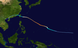
Tropical storm (39–73 mph, 63–118 km/h)
Category 1 (74–95 mph, 119–153 km/h)
Category 2 (96–110 mph, 154–177 km/h)
Category 3 (111–129 mph, 178–208 km/h)
Category 4 (130–156 mph, 209–251 km/h)
Category 5 (≥157 mph, ≥252 km/h)
Unknown

