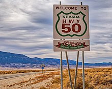
U.S. Route 50 in Nevada
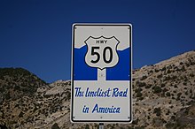
The Nevada portion crosses the center of the state and was named "The Loneliest Road in America" by Life magazine in July 1986.
The route crosses mostly desolate terrain in its journey across the state; US 50 passes through several large desert valleys and basins.
To crest some of the passes along US 50 requires navigating steep 8% grades and hairpin turns through pine forests to reach elevations of over 7,000 feet (2,100 m).
[3] In the stretch of highway between Fallon and Delta, Utah, a span of 409 miles (658 km), there are three small towns: Austin, Eureka, and Ely.
[4] This span is roughly the same distance as Boston, Massachusetts, to Baltimore, Maryland,[5] or Paris, France, to Zürich, Switzerland.
[7] In addition to portions being designated the Loneliest Road and Lincoln Highway, the portion concurrent with Interstate 580 in Carson City is designated the Carson City Deputy Sheriff Carl Howell Memorial Freeway in honor of a sheriff's officer who was shot to death while attempting to rescue a victim of domestic violence from her house.
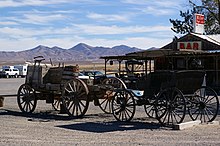
[17] The next services are in the single-building settlement of Middlegate, a roadhouse that has served as a restaurant, bar, hotel, and refueling station since the Pony Express era of the 19th century.
[18] The building features Lincoln Highway and Pony Express era artifacts as well as plaques from various historical societies confirming the station is authentic.
A reporter for the San Francisco Chronicle began to study the phenomenon of shoe trees after seeing the one at Middlegate, stating to his knowledge this was the biggest in the world.
[21][22] East of Middlegate, the paths of the Pony Express, Lincoln Highway, and US 50 diverge, using different passes to cross the Desatoya Mountains.
The city, founded by Pony Express riders who discovered silver, was a mining boomtown that now describes itself as a living ghost town.
[24] Perched above the town and just to the south of the highway is Stokes Castle, a long abandoned monument to a prominent eastern family with local mining interests.
[26] Past Eureka is Ely, founded as a stage coach station along the Pony Express and Central Overland Route.
These routes proceeded northeast towards Salt Lake City, while US 50 joins with US 6 and US 93 heading east towards the state line.
Officials from White Pine County decided to make the best of the publicity generated from the article, and convinced state authorities to do the same.
Jointly, they began to use the pejorative article as a platform to market the area for visitors interested in desert scenery, history, and solitude.
Visitors can mail in the completed passport and receive a certificate, signed by the Governor, certifying they survived The Loneliest Road in America.
[35] The 1971 road movie Vanishing Point, notable for its on-location filming across the southwest United States, used several sections of US 50 as part of the driving sequences.
King then heard a local legend about how the ghosts of Chinese miners, who died while trapped in a cave-in, can be seen crossing Highway 50 to haunt the city of Ruth.
[37][38] In 2002, Neil Peart, then taking a sabbatical from Rush, published Ghost Rider: Travels on the Healing Road, his account of a long-distance motorcycle journey across Canada and the United States.
He traveled across US 50 in Nevada, and remarked on the complete absence of any development on long stretches of the road, including a sign reading "No Services for 88 Miles.
The Pony Express used the technique of riders changing horses at stations approximately 10 miles (16 km) apart to maximize speed.
Utah officials refused to pave the portion of the Lincoln Highway west of Salt Lake City.
Nevada officials, and the Lincoln Highway Association, pleaded with Utah authorities to change their position, even offering funds to help offset the additional cost of paving that route.
However, the Lincoln highway directed travelers destined for both southern and northern California on a route away from Utah cities, towards central Nevada.
Utah instead paved the Wendover Cutoff, part of the Victory Highway (modern Interstate 80), that only directed traffic for northern California out of the state.
[48] The choice not to pave the Lincoln Highway would direct travelers bound for southern California to use the Arrowhead Trail (modern Interstate 15).
The final blow to the original route of the Lincoln Highway was the formation of the Dugway Proving Ground, a military base used for weapons testing, which closed the area to the public.
The improved route bypassed the ghost town of Osceola and entered Utah approximately 14 miles (23 km) to the south of the dirt road.
[55] The U.S. Forest Service still promotes this road for its historical value, but has announced that it will no longer be maintained and travel is only recommended by foot, horse, or four wheel drive vehicle.