U.S. Route 90 Business (New Orleans, Louisiana)
initially heads eastward along the Westbank Expressway, serving a number of suburban communities in Jefferson Parish located on the west bank of the Mississippi River.
The highway continues alongside the downtown area as part of the elevated Pontchartrain Expressway to a complex interchange with I-10 and mainline US 90 adjacent to the Superdome.
to be signed as Interstate 910 in the interim, the Louisiana Department of Transportation and Development did not follow through with an application to the AASHTO's U.S. Route Numbering Committee, and the designation remains unused.
becomes a developed commercial corridor, and an intersection with LA 18 Spur (Louisiana Street) provides a route for truck traffic to the industrial facilities along the riverfront.
The highway crosses from Westwego into the unincorporated community of Marrero immediately past Victory Drive and curves due east, maintaining a parallel trajectory to the Mississippi River.
At Carmadelle Street, several blocks past a signalized intersection with Westwood Drive, a ramp leads through traffic onto an elevated six-lane freeway, which begins in the median.
The ground-level portion of the Westbank Expressway continues straight ahead as frontage roads serving local businesses and maintains a six-lane capacity.
As it is located near the west end of the freeway, the interchange consists only of an eastbound entrance and westbound exit with the remaining movements accessed from the frontage roads.
Direct access to the facilities on the east side of the canal, situated along LA 3017 (Peters Road), is limited to a westbound exit ramp.
All remaining movements on exit 9 are provided via a partial cloverleaf interchange at General de Gaulle Drive with flyover ramps connecting to Terry Parkway, and the US 90 Bus.
General de Gaulle Drive is part of LA 428 and is the principal thoroughfare of Algiers, a name applied to the west bank section of New Orleans.
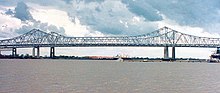
The highway curves due west to begin its ascent onto the Crescent City Connection, a pair of cantilever bridges each carrying four lanes of through traffic across the Mississippi River.
Several overlapping interchanges with limited movements further serve the business district, beginning with exit 12A (Camp Street), which passes between the National World War II Museum and Lee Circle.
In addition to being a significant downtown street, St. Charles Avenue is a scenic oak tree-lined boulevard that traverses uptown neighborhoods such as the Garden District and Carrollton.
Exit 12C connects with Loyola Avenue, a divided downtown thoroughfare that provides access to the Union Passenger Terminal and the city's two major entertainment venues—the Superdome and New Orleans Arena.
To the east, US 90 travels beneath the elevated I-10 as it passes through the downtown area en route to Slidell, located on the north shore of Lake Pontchartrain.
continues straight ahead to merge with westbound I-10, which swings to the northwest to proceed along the Pontchartrain Expressway toward New Orleans International Airport and the city of Baton Rouge.
Locally, westbound I-10 carries traffic between downtown New Orleans and the suburbs in Jefferson and St. Tammany parishes, the latter accessed via the Lake Pontchartrain Causeway.
While it contained automobile lanes that benefited through traffic on US 90 through the area, the bridge's location made it inconvenient for local travel between New Orleans and the developing communities on the opposite side of the river.
[12] During the 1930s, this once rural area was transformed into a booming industrial corridor focused along the Mississippi River and the Harvey Canal, which had become a link in the Gulf Intracoastal Waterway.
By 1942, the existing highway had become heavily congested, and the draw bridge crossing of the Harvey Canal was specifically cited as one of the worst traffic bottlenecks in the entire state.
[13] In 1946, the Louisiana Department of Highways engaged New York-based urban planner, Robert Moses, to study traffic patterns in the New Orleans metropolitan area and compile a report to address current and future transportation needs.
Moses' plan combined these elements into a continuous traffic artery and provided cost estimates as well as engineering evaluations by the New York firm of Andrews and Clark.
[11] Construction of the Westbank Expressway began in the vicinity of the Harvey Canal and forged a path largely along the southern edge of the west bank's existing development.
The frontage roads began at Louisiana Street in Westwego and continued to the Victory Drive interchange in Algiers, interrupted only at the Harvey Tunnel, through which only the central express lanes traveled.
)[20] Also opened was the first section of the Pontchartrain Expressway, New Orleans' first controlled access freeway, extending from the bridge to an interchange with US 90 (South Claiborne Avenue).
[23] In September 1960, the Westbank Expressway was completed westward from Barataria Boulevard to its interchange with US 90 near Avondale,[24][25] which involved filling in a section of Westwego's historic Company Canal.
[35] The original expressway lanes had been removed from that point through Westwego during the 1980s, leaving all traffic to utilize the existing service roads, which were improved and widened.
[3][38] By the 1970s, heavy traffic congestion on the Greater New Orleans Bridge and Pontchartrain Expressway led to the planning of a massive road project that would ultimately become the longest-running in the state's history.
A new exit serving the recently improved Tchoupitoulas Street corridor created a route for truck traffic associated with the Port of New Orleans that had formerly traversed residential uptown neighborhoods.