U.S. Route 9W
It begins in Fort Lee, New Jersey, as Fletcher Avenue crosses the US 1/9, US 46, and Interstate 95 (I-95) approaches to the George Washington Bridge, and heads north up the west side of the Hudson River to US 9 in Albany, New York.
However, some stretches in New Jersey and New York widen to four lanes, and much of the highway in Orange County is like an expressway even if not so designated.
Both roads run very near the top of the Palisades, occasionally offering views of New York City and the river.
Lemoine Avenue is heavy with commercial development in the Coytesville section of Fort Lee, but, as the road runs into Englewood Cliffs, it transitions to corporate office buildings.
Before the construction of the PIP, US 9W used to follow a route through the State Line Lookout at the New Jersey–New York border which is now accessible only from the parkway.
Across the state line, US 9W continues in Palisades as Highland Avenue, a two-lane road through mostly residential suburban surroundings.
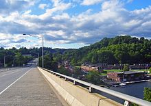
Running due north, it enters Nyack and meets with the New York State Thruway (I-87 and I-287) just west of the Tappan Zee Bridge.
The village is followed immediately by West Haverstraw, where US 202 comes in at an oblique angle and joins US 9W, creating the first concurrency along the route.
At Iona Island, it levels out again briefly and then US 9W/US 202 climbs to the heart of the state park at Bear Mountain Inn and Hessian Lake, where the Appalachian Trail crosses beneath the road in the only artificial tunnel along its entire route.
North of the circle, US 9W continues as a four-lane surface road, crossing Popolopen Creek and affording views of the similarly named Torne.
After becoming a four-lane expressway, NY 218 (Storm King Highway), the former route of US 9W, forks off to the right, carrying traffic to Highland Falls and the U.S. Military Academy (USMA) at West Point.
After passing Crow's Nest, Storm King and the rocky cliff faces of Butter Hill dominate the northward view.
It ascends gently past Delano-Hitch Stadium and the associated park to the center of its passage across Newburgh, the intersection with Broadway.
The road's climb continues until the North campus of Newburgh Free Academy, where it starts to descend to the busy exit at I-84, visible ahead, just west of the Newburgh–Beacon Bridge.
Development continues along the road, but there are increasingly large unbroken fields or woodlots and, finally, in the northern reaches of the town, orchards.
At Roseton, past the access road to the nearby powerplants, the highway reaches the county line just past the turnoff to the Gomez Mill House, the earliest surviving Jewish home in the U.S. Traffic is slowed when it passes through the hamlet of Marlboro, but otherwise there is little change in US 9W until it widens to four lanes again just south of the Mid-Hudson Bridge approach overpass.
The four lanes continue, however, for several more miles until well past the eastern terminus of NY 299, the road that carries traffic west toward the thruway and New Paltz.
It becomes more built up at Port Ewen, just south of Kingston, which it enters by crossing Rondout Creek via the John T. Loughran Bridge and becoming a four-lane expressway known as Frank Koenig Boulevard.
US 9W stays on a straight northward course, following alongside Esopus Creek but not crossing it, until it veers northeast to merge, once again, with NY 32.
As Malden Avenue, the highway continues north alongside the river once again, passing through the hamlet of Malden-on-Hudson on its way up into Greene County.
The route extended from the New Jersey state line at Orangetown and went northward through the Hudson Valley to the city of Albany.
[14][15] In the original 1925 plan for the U.S. Numbered Highway System, US 9 was designated along the west bank of the Hudson River from Fort Lee to Albany, utilizing Route 18N in New Jersey[16][17] and NY 10 in New York.
[20] The branch resumed at the northern New York City line as US 9E and continued to Waterford on what is now US 9 and US 4 along the eastern side of the river.
[22][23] US 9 was rerouted c. 1934 to follow US 9W and the George Washington Bridge to New York; as a result, US 9W was cut back to its current southern terminus in Fort Lee.
[29] The southernmost two miles (3.2 km) of the highway—from the bridge to just north of Fort Montgomery—utilized the existing right-of-way of US 9W,[30] which was widened from two to four lanes[29] and straightened through the construction of rock cuts.
[30] The portion of the bypass from Fort Montgomery to Cornwall-on-Hudson, with the exception of a one-mile (1.6 km) stretch northwest of Highland Falls, was constructed on a new alignment.
Like the section south of Fort Montgomery, the one-mile (1.6 km) stretch that utilized the original US 9W was widened to four lanes as well.
[37] In Albany, the north end of US 9W and part of US 9 would have been rerouted onto a proposed limited-access highway called the Mid-Crosstown Arterial.