Upper Pine Bottom State Park
Upper Pine Bottom Run was the site of a furnace for pig iron in 1814, the first sawmill was built on it in 1815, and in 1825 an earlier bridle path across its headwaters became a turnpike.
In addition to picnics, its chief use is as a parking area for local hunters, anglers, hikers, cross-country skiers, snowmobilers, and all-terrain vehicle riders.
Archeological evidence found in the state from this time includes a range of pottery types and styles, burial mounds, pipes, bows and arrows, and ornaments.
[3] Upper Pine Bottom State Park is in the West Branch Susquehanna River drainage basin, the earliest recorded inhabitants of which were the Iroquoian-speaking Susquehannocks.
[8] To fill the void left by the demise of the Susquehannocks, the Iroquois encouraged displaced tribes from the east to settle in the West Branch watershed, including the Shawnee and Lenape (or Delaware).
[16] The Wolfs' sawmill and the land they cleared for farming helped establish the unincorporated village of Waterville, which became the most significant population center in Cummings Township, and is about 2.5 miles (4.0 km) southeast of Upper Pine Bottom State Park.
The turnpike, which operated until 1860, had toll booths every 5 miles (8 km) and charged a horse-drawn wagon $1.68 to travel the entire road.
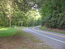
[13] Pennsylvania Route 44, which passes through the park, still follows the course of the former path and turnpike between Haneyville (at the western end of Upper Pine Bottom Run) and Coudersport (to the north).
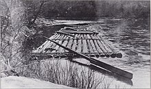
[21] The lumber era did not last; the old-growth forests were clearcut by the early 20th century and the Pine Creek Gorge was stripped bare.
[23] The soil was depleted of nutrients, fires baked the ground hard, and jungles of blueberries, blackberries, and mountain laurel covered the clearcut land, which became known as the "Pennsylvania Desert".
The largest section of the state forest covers 105,000 acres (42,000 ha) in the Pine Creek valley (and encircles the park).
The park was established by 1923 as "Upper Pine Bottom Class B Public Camp",[28] and named for the stream that flows through it.
Class B camps were on secondary highways and were "used primarily by hikers, hunters, fishermen, vacationists, and picknickers who desire to go far into the woods and make their stay comfortable".
[31][32] The CCC planted large numbers of trees in the state forest, did work in the park, and built a pavilion at the site in 1936.
In addition to picnics, its chief use is as a parking area for local hunters, anglers, hikers, cross country skiers, and snowmobilers.
Only Sand Bridge State Park, another picnic area to the south in Union County, is smaller, at 3 acres (1.2 ha).
Pine Creek had flowed northeasterly until then, but was dammed by rocks, soil, ice, and other debris deposited by the receding Laurentide Continental Glacier.
[40][41] The land on which Upper Pine Bottom State Park sits was part of the coastline of a shallow sea that covered a great portion of what is now North America about 300 million years ago, in the Pennsylvanian subperiod.
The high mountains to the east of the sea gradually eroded, causing a buildup of sediment made up primarily of clay, sand and gravel.
Tremendous pressure on the sediment caused the formation of the rocks that are found today in the Pine Creek drainage basin: sandstone, shale, conglomerates, limestone, and coal.
[41] Five major rock formations from the Devonian and Carboniferous periods are present in Upper Pine Bottom State Park and Cummings Township.
The youngest of these, which forms the highest points in the township, is the early Pennsylvanian Pottsville Formation, a gray conglomerate that may contain sandstone, siltstone, and shale, as well as anthracite coal.
Below this is the late Devonian and early Mississippian Huntley Mountain Formation, which is made of relatively soft grayish-red shale and olive-gray sandstone.
[42] January is the coldest month at Upper Pine Bottom State Park, July the warmest, and June the wettest.
The area had herds of American bison, elk and white-tailed deer, and large numbers of black bears, river otters, and beavers.
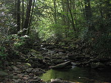
[50][51] Pine Creek and its tributaries were home to large numbers of fish, including trout, but dams downstream on the Susquehanna River have eliminated the shad and eels once found here by blocking their migrations.
[5] Habitat for land animals was destroyed by the clearcutting of forests, but there was also a great deal of hunting, with bounties paid for large predators.
[53] As of 2017[update] recreational opportunities within the 5-acre (2.0 ha) Upper Pine Bottom State Park were limited to picknicking and fishing.
The state forest trails are also open to mountain biking and horseback riding, and in winter are used for cross-country skiing and snowmobiling.