Vikos–Aoös National Park
It is named after the two major gorges of the area and encompasses 12,600 hectares (31,135 acres) of mountainous terrain, with numerous rivers, lakes, caves, deep canyons, dense coniferous and deciduous forest.
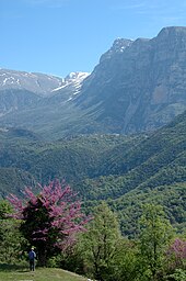
The Aoös gorge, Mt Tymphe (2,497 meters (8,192 ft) at Gamila peak), and a number of traditionally preserved settlements form the park's peripheral zone.
The park's remoteness and relatively small human population, combined with the great variation of biotopes and microclimatic conditions favors the existence of a rich variety of flora (1,800 species) in the area.
The area of the park has been sparsely populated throughout historical times, however from the 17th to the 19th century the local communities of Zagori acquired an autonomous status, flourished economically due to increased trade, and became a major center of folk medicine.
[18] During the large Middle Pleistocene glaciations, surface runoff from glacial meltwaters would have fed directly into the river channel network because much of the upland limestone terrain was covered by ice, and many conduits in the karst would have been choked with sediment or permanently frozen.
The biggest lake of the National Park, Drakolimni ("Dragonlake"), a formation that was created after the retreat of the glaciers,[23] is located at a height of 2,000 m (6,562 ft) on Mt Tymphe.
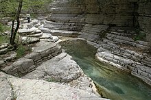
The lower slopes are dominated by younger flysch rocks, which consist of thin beds of graded sandstones intercalated with softer, fissile siltstones.
[27] Additional forms of glacial deposits, which extend down to 850 m (2,789 ft) above sea level,[28] include rock glaciers and limestone pavements.
[30] Historically, all the villages of the Zagori region were connected by a system of paths or small roads and they functioned more like a single entity rather than as separate communities.
(2) Combined areas of agricultural land with tree hedges and various woodlots, in addition to semi-open shrublands and rocky sites of the lower and middle slopes near human settlements.
[38] Recent studies on the flora of the National Park counted 873 vascular plants, including more than 250 medicinal, aromatic, and poisonous taxa.
The park's forests are abundant in species associated with the cool local climate, such as Wych Elm, Nettle-leaved Bellflower, Horse-chestnut and Large-leaved Linden.
[40] The woodland in the mountain area around the village of Papingo is characterized by the predominance of different juniper species, such as Juniperus communis, foetidissima, oxycedrus and excelsa.
[41] Studies on the non-vascular flora recorded the presence of about 150 moss species in the area of the national park, including one newly described taxon.
[43] The plants used in these recipes include the lemon balm Melissa officinalis, Tilia tomentosa, the spearmint Mentha spicata, the gas-plant Dictamnus albus, St John's Wort Hypericum perforatum, absinth Artemisia absinthium, the very popular Sideritis raeseri, known colloquially in Greece as “mountain tea”, and the elder bush Sambucus nigra.
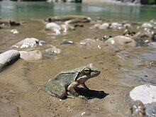
[5] Numerous species of large mammals such as wolves, foxes, wild horses, and roe deer are found in the area year-round.
Two bird communities that inhabit the subalpine and forest ecosystems are considered among the most complete in Greece:[5] The first community includes species that nest and feed in the subalpine area, like the alpine chough, shore lark, western rock nuthatch and alpine swift, while the second comprises birds of prey like the griffon vulture, Egyptian vulture, peregrine falcon and common kestrel, that search for food in a wider zone.
[52] During the 9th–4th centuries B.C., a small Molossian settlement existed between Monodendri and Vitsa, including stone houses and two cemeteries that have yielded important findings.
At that time the area of Zagori acquired an autonomous status inside the Ottoman Empire, whereby the locals were exempt from the heavy taxation that affected the lowland communities.
Many among them became members of successful professional classes before finally returning to their home villages, endowing the region with wealth and building luxurious mansions.
Moreover, the office of World Wide Fund for Nature (WWF) in the village of Papingo plays an essential role in management issues.
[29] Apart from the above-mentioned activities, dangers to the park include land erosion, landslides, and wildfires which threaten the local flora and fauna.
On the other hand, extreme geophysical conditions make the construction and maintenance of the necessary infrastructure network, mainly access routes and telecommunications, difficult.
The use of remote sensing and geographic information system techniques is of essential value for the park's management and constitutes the basis for further evaluations and impact analysis.
[58] The objective of the present state and regional policy is to carefully combine tourism development in the area with the preservation of its natural and cultural heritage.
[57] Specific objectives of ecotourism development include reviving traditional activities such as small-scale farming and stock-raising,[59] as well as establishing a network of communities of chamois biotopes.
[8] Characteristically, the Federation of Nature and National Parks of Europe (FNNPE) stated that "the need for a sustainable form of tourism has never been greater in the area".
Additional forms of adventure sports include climbing, hiking and mountain biking along local paths in order to observe the area's natural features and architecture.
[2][57] Popular trails in the region include the crossing of the Vikos Gorge, which lasts approximately six to seven hours and is considered of medium difficulty, as well as hiking around the peaks of Mt Tymphe.