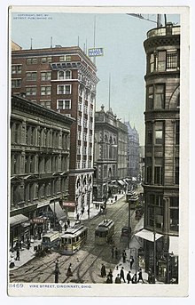
Vine Street, Cincinnati
It heads mostly north-northeast from the riverfront area through the Over-the-Rhine neighborhood, ascending between Clifton Heights and Mount Auburn until it courses the uptown plateau past the University of Cincinnati.
An adjunct, known as Short Vine, essentially parallels Jefferson Avenue and functions as a central artery of the neighborhood of Corryville, an off-campus business district with a number of shops, music venues, and restaurants.
[1] Vine Street and Jefferson Avenue were both realigned in the 1970s to provide a bypass around the Corryville Neighborhood Business District.
Vine continues in a northerly direction through the Cincinnati city neighborhood of Carthage, where it merges with Ohio State Route 4 at the terminus of Paddock Road.
Passing on through the Cincinnati neighborhood of Hartwell, Vine Street then becomes Springfield Pike when it enters Wyoming, Ohio.