Virgin Islands National Park
[5] As stated in the foundation document:[6] The purpose of Virgin Islands National Park is to preserve and protect for public benefit and inspiration outstanding scenic features, Caribbean tropical marine and terrestrial ecosystems in their natural conditions, and cultural heritage from pre-Columbian through Danish colonial times.In 1956, Laurance Rockefeller's Jackson Hole Preserve donated its extensive lands on the island to the National Park Service, under the condition that the lands had to be protected from future development.
The remaining portion, the Caneel Bay Resort, operates on a lease arrangement with the NPS, which owns the underlying land.
[7] The property includes beaches, undisturbed forest as well as historic Danish colonial and Taíno Indian artifacts.
[9] In 2012, the National Park Service purchased 58 acres from the trust for $2.25 million, using money from the federal Land and Water Conservation Fund.
The Bordeaux Mountain Trail is a steep and rocky path leading from Little Lameshur Bay to the highest point of the island.
The 1 mile (1.6 km) long Lind Point Trail begins in Cruz Bay, behind the Virgin Islands National Park Visitor Center.
A wooden observation platform is at the summit with views of St. John, St. Thomas, Jost Van Dyke, and many smaller islands.
Beginning at Salt Pond Bay, the Ram Head Trail travels about 1 mile (1.6 km) down a dry and rocky peninsula to the southernmost point on St. John.
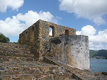
The Annaberg Historic District protects a partially restored sugar factory and windmill located just east of Mary's Point.
National park signage guides visitors through the ruins and explains the process of turning sugar cane into molasses.
The windmill is located on Annaberg Point, which offers views of Tortola, Great Thatch Island, and the Narrows.
[20] Virgin Islands National Park encompasses 14,737 acres (5,964 ha; 23 sq mi) of land and ocean.
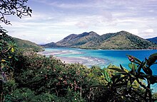
The main features are coral reefs, which almost completely surround the park, and the ocean waters, tropical forests and beaches.
Wild donkeys, deer, mongoose, pigs, goats, birds, iguanas, skinks, tortoises, frogs, fish, and crabs inhabit the park.
The park has been recognised as an Important Bird Area (IBA) by BirdLife International because it supports populations of bridled quail-doves, green-throated caribs, Antillean crested hummingbirds, brown pelicans, Caribbean elaenias, Puerto Rican flycatchers, pearly-eyed thrashers and Lesser Antillean bullfinches.
Class A tropical climates have an average temperature of 18 °C (64.4 °F) or higher in every month of the year, with significant annual precipitation.
Igneous activity then changed to that of an island arc, characterized by the Louisenhoj Formation, consisting of andesite and basalt.
Volcanism resumed as evidenced by the Late Cretaceous Tutu Formation, consisting of volcaniclastic turbidites, basalt, and andesite.
The Late Eocene saw the intrusion of Narrows pluton and Virgin Gorda batholith, associated with the Greater Antilles arc magmatism, and more compressive folding associated with the spreading of the Cayman Trough.