Volcanism of Eastern Canada
The most capable[clarification needed] large igneous provinces in Eastern Canada are Archean (3,800-2,500 million years ago) age greenstone belts containing a rare volcanic rock called komatiite.
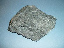
[1] Komatiite lavas in the Abitibi greenstone belt (pictured) occur in four lithotectonic assemblages known as Pacaud, Stoughton-Roquemaure, Kidd-Munro and Tisdale.
[6] A failed arm extends 150 km (93 mi) north into mainland Ontario where it forms a geological formation known as the Nipigon Embayment.
The source for this volcanism was a long-lived and stationary area of molten rock called the New England or Great Meteor hotspot.
[9][10] The lack of a noticeable hotspot track west of the Monteregian Hills might be due either to failure of the New England mantle plume to pass through massive strong rock of the Canadian Shield, the lack of noticeable intrusions, or to strengthening of the New England mantle plume when it approached the Monteregian Hills region.
[11] About 250 million years ago during the early Triassic period, Atlantic Canada lay roughly in the middle of a giant continent called Pangaea.
[12] This supercontinent began to fracture 220 million years ago when the Earth's lithosphere was being pulled apart from extensional stress, creating a divergent plate boundary known as the Fundy Basin.
As the Fundy Basin continued to form 201 million years ago, a series of basaltic lava flows were erupted, forming a volcanic mountain range on the mainland portion of southwestern Nova Scotia known as North Mountain, stretching 200 km (124 mi) from Brier Island in the south to Cape Split in the north.
[14] However, North Mountain is the remnants of a larger volcanic feature that has now been largely eroded based on the existence of basin border faults and erosion.
[14] The Fogo Seamounts, located 500 km (311 mi) offshore of Newfoundland to the southwest of the Grand Banks, consists of submarine volcanoes with dates extending back to the Early Cretaceous period at least 143 million years ago.